
�������: 1-15 ���鵽��֪ʶ�� ��ѧ RS����ؼ�¼37�� . ��ѯʱ��(0.046 ��)

��ظ�ԭ�����ڶ࣬����Ϊ ������ˮ�������������Լռȫ�������������57.6%�����ҹ���Ҫ�ĺ����ֲ���֮һ����20����90���ĩ��������ȫ���ůӰ�죬��ظ�ԭ��������½���������������ƣ��ϲ��ĺ�������һ��ή������ظ�ԭ����½�����������λ��ƫԶ�������ܵ�����Ӱ�죬����䶯̬�仯���Ժܺõط�ӳ������仯�Ժ�����Ӱ�죬������仯����Ҫ��ָʾ������

������������ϵ�д��͵͵����������ƻ���������ʵʩ���硰StarLink����SpaceX�ġ�������������Kuiper��������ѷ�ġ���������������Starnet�����й������������ȣ����ؿռ�Ŀ���������ֱ�ըʽ��������Կռ�����Ĺ۲��Ӱ������ͻ����
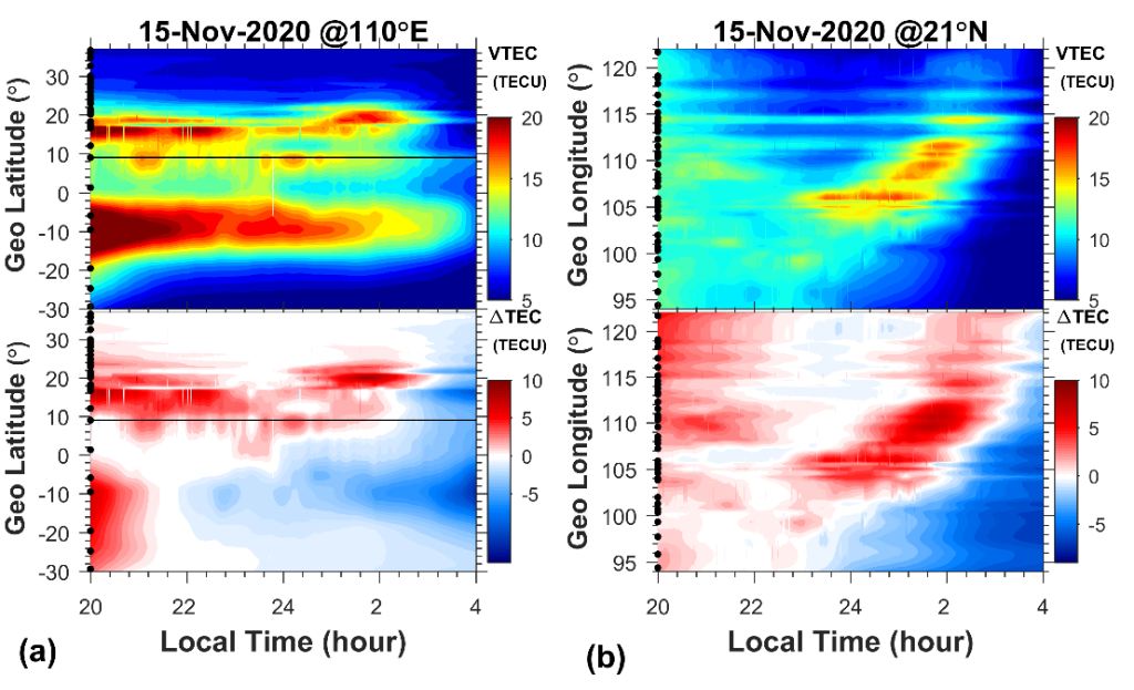
���������������������λ������ͨ�ŵȼ���������Щ����Ӧ�õ��ȶ��ԡ���ȷ�Ե�����Խ��Խ�ߡ���ˣ�ؽ���һ����ʶ�����Ŀռ�ṹ�������������������γ�Ⱥ;��ȱ仯�ĸ��ӿռ�ṹ����Щ�ռ�ṹ�������ս����ξ�ȷ����������״̬��Ҳ�Ե�����λ���粨ͨ�š�����ң�еȼ���������ҪӰ�졣������ܵ��Ӻ�����TEC���͵����ܶ�����ȹ۲������ڷ��ݹ����ж��������ˮƽ���ȣ��ڴ��ڿռ�ṹʱ���ɻ�����Ӱ���̽������...
���-RS���϶��ĺź�������������֤ʵ�������SPA����������ɵ�Լ����ͼ��
�϶��ĺ� ���������� ������֤ʵ�� ����SPA��������
2023/1/16
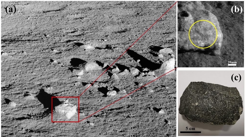
���ö���Ѳ��������������湤���˳���40�����磬����صĺ����������ǣ�VNIS������Ѳ����������·���Ѳ�ö��λ�õĺ������������ݡ�VNIS �������о���½���������±���ʯ�ɷֲ�������Դ����Ҫ������Ȼ����̫�շ绯��������С����ɢ�䡢�����Ĺ�����Ӧ�۲����������ض���Ӱ��������������������������������ݼ���õ��Ŀ���ɷִ��ںܴ�ȷ���ԡ�
STUDY ON KARST INFORMATION IDENTIFICATION OF QIANDONGNAN PREFECTURE BASED ON RS AND GIS TECHNOLOGY
Karst Landsat-5 TM Image RS+DEM Slope Karst Rocky Desertification
2018/5/16
Karst area is a pure natural resource base, at the same time, due to the special geological environment; there are droughts and floods alternating with frequent karst collapse, rocky desertification a...
DETERMINATION AND CHARACTERISATION OF FAULT SYSTEMS AND GEOMORPHOLOGICAL FEATURES BY RS AND GIS TECHNIQUES IN THE WSW PART OF TURKEY
Remote Sensing Geology Geomorphology Western Anatolia Earthquakes DEM/DTM Applications
2015/7/30
This article is aimed to give the first results of the project studying the faults and tectonic style of the southwestern part of Turkey
based on remote sensing techniques. LANDSAT-TM and ASTER sate...
Monitoring of bank line erosion of River Ganga, Malda District, and West Bengal: Using RS and GIS compiled with statistical techniques
River Migration banks failure paradigm shift mitigation of disasters
2014/11/26
The creation of regional imbalance, inequalities and differentiation in India, starts with the
physiographic element and ends with economic, and socio-cultural parameters of the
inhabitants/popula...
����Ƶ��Ԥ������RS��ä���ʶ��
RS�� ��������Ҷ�任 ä�����ʶ��
2014/4/10
���RS(Reed Solomon)���ä�����ʶ�����⣬�����һ�ֻ���Ƶ��Ԥ�����ļ�ⷽ�����÷�������RS���Ƶ��������ʵ�ֶ�RS���ä�����ʶ����Ը�����������Զ������ֵ�Ƶ�������з����Ա任����ֵ�˲�������������ֱ任Ƶ��ͳ����Ϣ��ʹ�ü���㷨������Ӧ�ϸߵ����뻷����ͬʱ�������㷨������Ӧ�������������ޡ�����ʵ��������㷨�ܹ��ڽϸ�������������ʵ�ֶԱ�ԭRS���ä�����ʶ�������ѽӽ�...
RS��GIS֧�ֵĺ�ӵ���ʪ����̬��������
ң�� ������Ϣϵͳ ʪ�� ��̬��������
2011/7/26
�鷺ƽԭ��ˮ��Ȼʪ�ض�����̬�����Ա���������Ҫ���塣��ǰ��Ȼʪ���ձ���������仯���������ź�Ӱ��,����̬������״�����˵���,����µĵ�ѧ��Ϣ����̽����Ȼʪ����̬�������۷�������������Ҫ���塣ѡ��λ������ƽԭ�������ĺ�ӹ��Ҽ���Ȼ������ʪ�ؼ����ܱ�ũ��ʪ��Ϊ�о���,����ң�к͵�����Ϣϵͳ����֧��,���Ұ����̬������ˮ������������,��ˮ�ĵ�ò���������������������Ŷ�3����ѡȡһϵ������ָ������,...
��������SCS����ģ�͵�һ����Ҫ����,ģ���о��߽���ֵ��=0.2��Ϊģ�͵IJ���ֵ����ģ�Ͳ���û�п��ǵ�ò���ͶԲ�����Ӱ��,��˹�ص�����ͬ��ò�����µر��¶ȡ������ȡ��ز����ԡ�������϶�ķ����̶ȵȷ�������ںܴ���,����Щ���ض�ֱ��Ӱ��������IJ������ơ��ڿ��ǵ�ò���ͶԿ�˹���������Ӱ��Ļ�����,ͨ���ʶ���ͬ��ò�����µĦ�ֵ��SCSģ�ͽ��иĽ�����GIS��RS������Ϊ��ȡ�����ò���͡��������ͺ�...
Ϊ��߸������Ͽͻ���ʧԤ��ľ���,�����˻���SMC-�ֲڼ�-��С����֧���������ĵ�������ͻ���ʧԤ��ģ��.��ģ����������SMCģ�ͼ�����ͻ���Ծ��,��0.5Ϊ��ֵ�жϳ��ͻ���ʧ״̬,ʶ������пͻ��ʹ��пͻ�;���Ӧ�ôֲڼ�����Լ�����Ҫ�Ŀͻ���ʧԤ��ָ����ϵ,Ȼ��ѵ������������С����֧������������ѧϰ��ѵ��,�����Բ��������Ŀͻ���ʧ״̬�����б�.����ij�����̳���2525���ͻ��������е��������...
������Fourier�任,�ڽ��������¸����˦�(x)��L2(Rs)�������߶Ⱥ�����һ����ֱ�Ҫ����.��һ��, ���� {���� } ������С��, ������С����Fourier�任��֧����
�Ȧ� supp{�צ�} = ��si=1[Ai, Di] - ��si=1(Bi, Ci), Ai �� Bi �� Ci �� Di, i =1, 2, �� , s.
��������������ÿһ�� |�צ�| �ڦ� �� ...
DEM-RS-GIS BASED STORM RUNOFF HYDROGRAPH ESTIMATION FOR THE HEART RIVER SUB-BASIN, MISSOURI RIVER BASIN
Remote sensing Normalized Difference Vegetation Index geographic information system
2009/10/12
Accurate representation of the physical and biological features of the landscape within the watershed is required as the extent and type of watershed cover affects the movement of water in the hydrolo...
Unravelling the Nature of HD 81032 �C A New RS CVn Binary
Star-X-ray star-variable star-late-type star-HD 81032
2009/5/12
BVR photometric and quasi-simultaneous optical spectroscopic
observations of the star HD81032 have been carried out during
the years 2000�C2004. A photometric period of 18.802 �� 0.07d has been
dete...
GIS/RS-Based Flood Risk Mapping for the Eastern Honghu Flood Diversion Area
Honghu flood diversion area flood inundation estimation flood risk mapping
2008/12/2
A first case study for the estimation of flood damages in the eastern Honghu flood diversion area is presented in this paper. The results display flood risk zones based on simulated estimation depths....
�й��о����������а�-��
- ���ڼ���...
�й�ѧ���ڿ����а�-��
- ���ڼ���...
�����ѧ���л������а�-��
- ���ڼ���...
�й���ѧ���а�-��
- ���ڼ���...
�ˡ���-ƪ
- ���ڼ���...
�Ρ���-ƪ
- ���ڼ���...
��������-ƪ
- ���ڼ���...
�������� -ƪ
- ���ڼ���...
֪ʶҪ��-ƪ
- ���ڼ���...
���ʶ�̬-ƪ
- ���ڼ���...
��������-ƪ
- ���ڼ���...
ѧ��ָ��-ƪ
- ���ڼ���...
ѧ��վ��-ƪ
- ���ڼ���...