搜索结果: 1-15 共查到“林学 Satellite”相关记录19条 . 查询时间(0.056 秒)
Grouping-Based Time-Series Model for Monitoring of Fall Peak Coloration Dates Using Satellite Remote Sensing Data
phenology monitoring fall foliage coloration grouping-based time-series analysis spatial and temporal scale optical remote sensing
2024/1/12
Accurate monitoring of plant phenology is vital to effective understanding and prediction of the response of vegetation ecosystems to climate change. Satellite remote sensing is extensively employed t...
Monitoring Three-Decade Expansion of China's Major Cities Based on Satellite Remote Sensing Images
urbanization satellite remote sensing urban expansion trajectories urban village north-south differentiation
2024/1/12
As the largest developing country, China has experienced dramatic urban expansion since the "reform and opening-up" policy started at the end of the 1970s. In this paper, we monitor three decades of u...
Monitoring hourly night-time light by an unmanned aerial vehicle and its implications to satellite remote sensing
Night-time light Unmanned aerial vehicle Hourly dynamic Urban function Spectral analysis
2023/12/21
Satellite-observed night-time light in urban areas has been widely used as an indicator for socioeconomic development and light pollution. Up to present, the diurnal dynamics of city light during the ...
Astrape: A System for Mapping Severe Abiotic Forest Disturbances Using High Spatial Resolution Satellite Imagery and Unsupervised Classification
astrapeforest disturbanceSentinel-2planetdoveimage segmentation RSGISLibjenksXGBoost
2023/12/6
Severe forest disturbance events are becoming more common due to climate change and many forest managers rely heavily upon airborne surveys to map damage. However, when the damage is extensive, airbor...
Synthesizing Disparate LiDAR and Satellite Datasets through Deep Learning to Generate Wall-to-Wall Regional Inventories for the Complex, Mixed-Species Forests of the Eastern United States
LiDAR airborne laser scanning enhanced forest inventory aboveground biomass forest carbon deep learning Maine New Hampshire Vermont Massachusetts Connecticut Rhode Island
2023/12/5
Light detection and ranging (LiDAR) has become a commonly-used tool for generating remotely-sensed forest inventories. However, LiDAR-derived forest inventories have remained uncommon at a regional sc...
Satellite–Derived Topography and Morphometry for VHR Coastal Habitat Mapping: The Pleiades–1 Tri–Stereo Enhancement
leiades–1 photogrammetry RSP topography classification maximum likelihood landscape
2023/12/4
The evolution of the coastal fringe is closely linked to the impact of climate change, specifically increases in sea level and storm intensity. The anthropic pressure that is inflicted on these fragil...
Tropical Forest Disturbance Monitoring Based on Multi-Source Time Series Satellite Images and the LandTrendr Algorithm
Hainan Island forest disturbances LandTrendr Google Earth engine
2023/11/22
Monitoring disturbances in tropical forests is important for assessing disturbance-related greenhouse gas emissions and the ability of forests to sequester carbon, and for formulating strategies for s...
MONITORING SPATIAL AND STRUCTURAL CHANGES OF FOREST COVER IN YENICIFTLIK WATERSHED WITH MULTITEMPORAL SATELLITE DATA
Remote Sensing Monitoring Forest Resources Natural Resources Planning Change Detection Landsat
2015/7/29
Recent surveys indicate that changes in forest cover and land use have a direct and enormous effect on wildlife, water quality, climate
and carbon cycling. The forest ecosystem is threatened constan...
FOREST CANOPY DENSITY MONITORING, USING SATELLITE IMAGES
Remote Sensing Forestry Change Detection Landsat Multispectral Thermal
2015/7/29
The increasing use of satellite Remote Sensing for civilian use has proved to be the most cost effective means of mapping and
monitoring environmental changes in terms of vegetation and non-renewabl...
Assessment of some forest characteristics employing IKONOS satellite data
texture categorial knowledge vegetation cover
2015/3/6
In recent years, satellite remote sensing has become a new tool for estimation of forest condition. The paper deals with spruce timber growing stock and vegetation cover assessment employing IKONOS sa...
Object-oriented classification of Ikonos satellite data for the identification of tree species composition
automated image analysis eCognition median filters
2015/3/3
This paper describes the automated classification of tree species composition from Ikonos 4-meter imagery using an object-oriented approach. The image was acquired over a man-planted forest area with ...

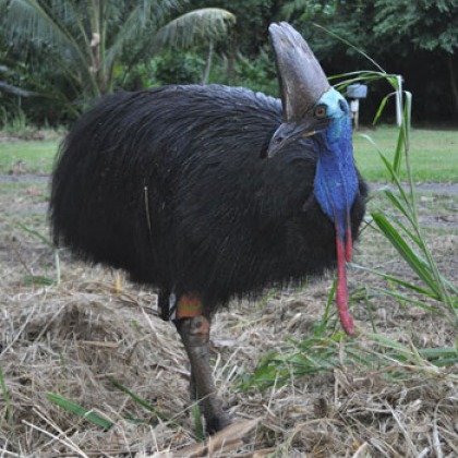
Wildlife researchers say they are making the cassowary conservation dollar go further by tracking the birds with satellite tags.
Determining Seasonal Variation in Bamboo Forest Spectral Reflectance Using Satellite- and Ground-based Data
bamboo forest LANDSAT/TM NDVI seasonal variation spectra SPOT/HRV
2009/8/28
Seasonal variation in the spectra of bamboo, broadleaved forests, and coniferous forests was examined using multi-temporal SPOT/HRV and LANDSAT/TM data and ground-based spectral measurements. The sate...
Characteristics of Band and Luminance and Classification of the Tree Vigor of Aged, Large-diameter Japanese Red Pine (Pinus densiflora) Using High-resolution IKONOS Satellite Data
IKONOS Japanese red pine remote sensing tree vigor
2009/8/27
The relationships between characteristics of band and luminance and classification of the tree vigor of aged, large-diameter Japanese Red Pine was performed using high-resolution IKONOS satellite data...
Uses of High Spatial Resolution Satellite Data to Forest Monitoring
extraction of single tree forest damage high resolution satellite data object-oriented classification
2009/8/21
This paper describes the characteristics of high resolution satellite data, methods to observe single trees and forest stands using it, and the results of previous studies. It also introduces its appl...

