
�������: 1-15 ���鵽������ѧ���� 3D����ؼ�¼865�� . ��ѯʱ��(0.796 ��)
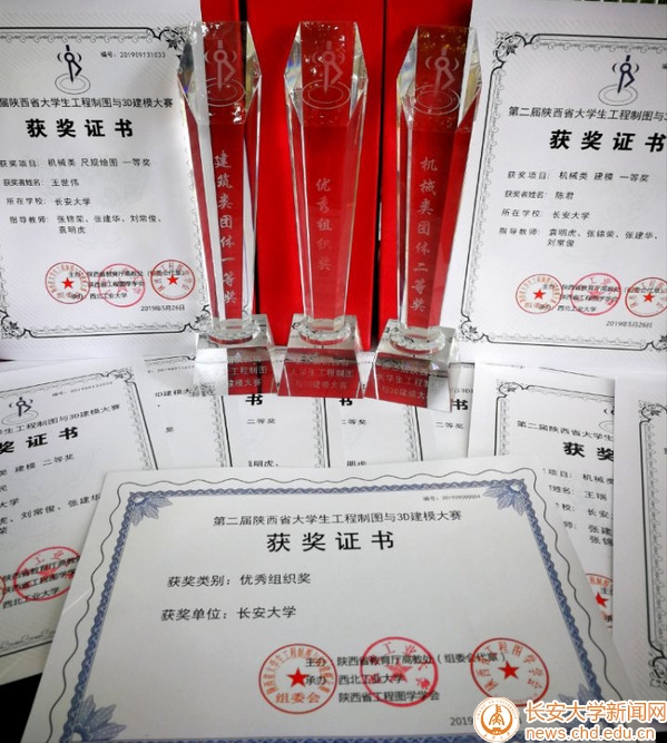
2019��5��24��26�գ�������ʡ�������̴߽����죬������ҵ��ѧ�а������ʡ�ڶ��칤����ͼ��3D��ģ������������ҵ��ѧ����У�����С���У15�˴�����ȡ���˽����������һ�Ƚ�����е���������Ƚ��Լ�����������ġ������ᡱ����ɼ�����У������������֯�����������е�ࡢ��������������漰�߹��ͼ����ά��ģ��������������塢����߹���ͼ����ģ��һ���������Ƚ�������ȫʡ����ȫ��985��211��...
FOVEON VS BAYER: COMPARISON OF 3D RECONSTRUCTION PERFORMANCES
Photogrammetry Bayer pattern accuracy de-mosaicking point cloud structure light scanner
2019/3/4
The main idea of this particular study was to validate if the new FOVEON technology implemented by sigma cameras can provide better overall results and outperform the traditional Bayer pattern sensor ...
SEMANTIC PHOTOGRAMMETRY �C BOOSTING IMAGE-BASED 3D RECONSTRUCTION WITH SEMANTIC LABELING
image-based 3D reconstruction label transfer semantic photogrammetry dense image matching
2019/3/4
Automatic semantic segmentation of images is becoming a very prominent research field with many promising and reliable solutions already available. Labelled images as input for the photogrammetric pip...
3D CAMERAS ACQUISITIONS FOR THE DOCUMENTATION OF CULTURAL HERITAGE
spherical photogrammetry indoor mapping SLAM RGB-D data accuracy comparison
2019/3/4
Photography has always been considered as a valid tool to acquire information about reality. Nowadays, its versatility, together with the development of new techniques and technologies, allows to use ...
SURVEY, STRATIGRAPHY OF THE ELEVATIONS, 3D MODELLING FOR THE KNOWLEDGE AND CONSERVATION OF ARCHAEOLOGICAL PARKS: THE CASTLE OF AVELLA
archaeology of architecture medieval fortifications ront orthophotos
2019/3/1
The site of Avella is a precious example of ruined medieval fortification with territorial and landscape values. The width and vulnerability of its masonry remnants require a systematic survey and phy...
A REVIEW OF 3D GIS FOR USE IN CREATING VIRTUAL HISTORIC DUBLIN
Historic City Modelling GIS HBIM Laser Scanning
2019/3/1
This paper illustrates how BIM integration with GIS is approached as part of the workflow in creating Virtual Historic Dublin. A design for a WEB based interactive 3D model of historic buildings and c...
EXTENDING INDOOR OPEN STREET MAPPING ENVIRONMENTS TO NAVIGABLE 3D CITYGML BUILDING MODELS: EMERGENCY RESPONSE ASSESSMENT
Emergency evacuation responses Digital data management
2018/11/9
Disaster scenarios in high-rise buildings such as the Address Downtown, Dubai or Grenfell Tower, London have showed ones again the importance of data information availability for emergency management ...
THE URBAN HERITAGE CHARACTERIZATION USING 3D GEOGRAPHIC INFORMATION SYSTEMS. THE SYSTEM OF MEDIUM-SIZED CITIES IN ANDALUSIA
Cultural Heritage Intermediate Cities Urban and Territorial Studies Urban Parameters
2018/11/9
The primary objective of this paper is to approach the use of the 3D Geographic Information Systems (3D GIS), as an instrumental tool that allows us to deal efficiently with the extensive amount of in...
A USABILITY EVALUATION OF A 3D MAP DISPLAY FOR PEDESTRIAN NAVIGATION
Pedestrian Navigation LOD 3D 2D Usability
2018/11/9
This paper is focused to address the map display usability for finding given POI addresses in a popular urban city area. LOD 1 of 3D representations of city buildings are presented into a 2.5D map for...
STUDY ON PRACTICAL TECHNOLOGIES OF AERIAL TRIANGULATION FOR REAL SCENE 3D MOELING WITH OBLIQUE PHOTOGRAPHY
Oblique Photography Aerial Triangulation quality factors POS data camera calibration connection point matching
2018/5/11
The key technologies in the real scene 3D modeling of oblique photography mainly include the data acquisition of oblique photography, layout and surveying of photo control points, oblique camera calib...
AN INTEGRATED PHOTOGRAMMETRIC AND PHOTOCLINOMETRIC APPROACH FOR PIXEL-RESOLUTION 3D MODELLING OF LUNAR SURFACE
Moon 3D Modelling Photogrammetry Photoclinometry Image Matching Shape from Shading
2018/5/15
High-resolution 3D modelling of lunar surface is important for lunar scientific research and exploration missions. Photogrammetry is known for 3D mapping and modelling from a pair of stereo images bas...
USE OF FISHEYE PARROT BEBOP 2 IMAGES FOR 3D MODELLING USING COMMERCIAL PHOTOGRAMMETRIC SOFTWARE
Fisheye Distortions Camera Calibration Parrot Bebop 3D modelling Agisoft PhotoScan Pix4D Mapper
2018/6/4
Fisheye camera installed on-board mass market UAS are becoming very popular and it is more and more frequent the use of such platforms for photogrammetric purposes. The interest of wide-angles images ...
3D MODELLING OF A HISTORICAL BUILDING USING CLOSE-RANGE PHOTOGRAMMETRY AND REMOTELY PILOTED AIRCRAFT SYSTEM (RPAS)
RPAS Close-range Photogrammetry 3D Modelling Historical Building
2018/6/4
The photogrammetric survey of architectural Cultural Heritage is a very useful and standard process in order to obtain accurate 3D data for the documentation and visualization of historical buildings....
3D CULTURAL HERITAGE DOCUMENTATION: A COMPARISON BETWEEN DIFFERENT PHOTOGRAMMETRIC SOFTWARE AND THEIR PRODUCTS
Cultural Heritage Data Repositories Emergency Photogrammetric workflow Photogrammetric software comparison Dense cloud validation Terrestrial Laser Scanner
2018/6/4
The conservation of Cultural Heritage depends on the availability of means and resources and, consequently, on the possibility to make effective operations of data acquisition. In facts, on the one ha...
ANCIENT SHIPYARD ON TURKEY��S DANA ISLAND: ITS 3D MODELLING WITH PHOTOGRAMMETRY AND COMPUTER GRAPHICS
Ancient shipyard 3D Modelling Photogrammetry Computer Graphics Visualization
2018/6/4
Although a small island 2 km off the southern coast of Turkey, Dana Island offers a rich history which is likely to shed light upon the Dark Ages. Starting from 2015 our archaeological team discovered...
�й��о����������а�-��
- ���ڼ���...
�й�ѧ���ڿ����а�-��
- ���ڼ���...
�����ѧ���л������а�-��
- ���ڼ���...
�й���ѧ���а�-��
- ���ڼ���...
�ˡ���-ƪ
- ���ڼ���...
�Ρ���-ƪ
- ���ڼ���...
��������-ƪ
- ���ڼ���...
�������� -ƪ
- ���ڼ���...
֪ʶҪ��-ƪ
- ���ڼ���...
���ʶ�̬-ƪ
- ���ڼ���...
��������-ƪ
- ���ڼ���...
ѧ��ָ��-ƪ
- ���ڼ���...
ѧ��վ��-ƪ
- ���ڼ���...