搜索结果: 1-15 共查到“地质学 land”相关记录16条 . 查询时间(0.453 秒)

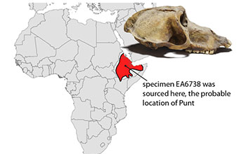
Mummified baboons reveal likely location of fabled land of Punt, far reach of early Egyptian mariners(图)
Mummified baboons likely location fabled land Punt far reach early Egyptian mariners
2021/1/8
The fabled land of ancient Punt was a major trading partner of Egypt's for at least 1,100 years. Punt was an important source of luxury goods, including incense, gold, leopard skins and living baboons...

Remote Hawaiian island harbors last land snails of their kind(图)
Remote Hawaiian island harbors last land snails their kind
2020/12/31
The island of Nihoa, a slice of jagged rock that juts out of the Pacific Ocean, is the sole refuge for a rediscovered species of native Hawaiian land snail previously presumed to be extinct.First reco...

New native Hawaiian land snail species discovered(图)
New native Hawaiian land snail species discovered
2020/7/31
Scientists at the Florida Museum of Natural History and other institutions have discovered a new native Hawaiian land snail species, sounding a rare, hopeful note in a story rife with extinc...
STUDIES AND APPLICATION OF REMOTE SENSING RETRIEVAL METHOD OF SOIL MOISTURE CONTENT IN LAND PARCEL UNITS IN IRRIGATION AREA
Land Parcel Unit Soil Moisture Content Remote Sensing Retrieval Water Resource Management Irrigation Area
2018/5/17
Soil moisture is one of the important hydrological elements. Obtaining soil moisture accurately and effectively is of great significance for water resource management in irrigation area. During the pr...
A MULTI-SOURCE DATA APPROACH FOR THE INVESTIGATION OF LAND SUBSIDENCE IN THE KONYA BASIN, TURKEY
Remote Sensing Differential SAR Interferometry (DInSAR) Small BAseline Subset (SBAS) GRACE Subsidence Sinkholes Groundwater Turkey
2018/4/18
Groundwater depletion caused by rapid population growth, global climate change, water resources overexploitation is a major concern in many regions of the world. Consequences are not limited to a non-...
A MULTI-SOURCE DATA APPROACH FOR THE INVESTIGATION OF LAND SUBSIDENCE IN THE KONYA BASIN, TURKEY
Remote Sensing Differential SAR Interferometry (DInSAR) Small BAseline Subset (SBAS) GRACE Subsidence Sinkholes Groundwater Turkey
2018/5/8
Groundwater depletion caused by rapid population growth, global climate change, water resources overexploitation is a major concern in many regions of the world. Consequences are not limited to a non-...
Vision,not limbs,led fish onto land 385 million years ago
Vision not limbs led fish onto land 385 million years ago
2017/3/30
EVANSTON - A provocative new Northwestern University and Claremont McKenna, Scripps and Pitzer colleges study suggests it was the power of the eyes and not the limbs that first led our ancient aquatic...
Recreating ancient vertebrate's first step on dry land
ancient vertebrate first step dry land
2016/7/15
Could a tail have allowed ancient vertebrates to make the transition from water to land?Reporting in Science today, researchers from Georgia Institute of Technology, Carnegie Mellon Universi...
Strolling salamanders provide clues on how animals evolved to move from water to land
Strolling salamanders animals evolved water to land
2015/12/8
Around 390 million years ago, the first vertebrate animals moved from water onto land, necessitating changes in their musculoskeletal systems to permit a terrestrial life. Forelimbs and hind limbs of ...
Stochastic simulation of soil water status on reclaimed land in northern Alber
E. geostatistics spatial variability semi-variogram uncertainty
2015/8/11
Studies of spatial variability and simulation of available soil water and extractable soil water are scarce and yet such data are essential in hydrologic and solute transport modeling. A study was con...
A RATIONAL APPROACH TO DIGITAL ANCILLARY DATA ACCESS AND VISUALIZATION IN LAND COVER, LAND USE PROJECTS
Land Cover Land Use Interpretation aerial photographs Rectification Orthorectification database GIS
2015/7/29
During the last decade many national and regional Land Cover/Land Use projects are implemented based on computer aided satellite
image interpretation. An essential procedure for the European CORINE ...
CHANGES IN THE LAND COVER AND LAND USE OF THE ITACAIúNAS RIVER WATERSHED, ARC OF DEFORESTATION, CARAJáS, SOUTHEASTERN AMAZON
Landsat, change detection, object based image analysis
2015/5/7
Human actions are changing the Amazon’s landscape by clearing tropical forest and replacing it mainly by pasturelands. The focus of this work is to assess the changes in the Itacaiúnas River watersh...
MAPPING AND ASSESSING LAND USE/ LAND COVER CHANGE IN MUHARRAQ ISLAND BASED ON GIS AND REMOTE SENSING INTEGRATION
Mapping land use land cover GIS Remote Sensing Muharraq City Bahrain
2014/4/24
In this study, Remote Sensing (RS) and Geographic Information Systems (GIS) techniques were integrated to map out and assess the
changes of Land Use/Land Cover (LULC) maps in Muharraq Governorate (I...
Land Use Patterns Effect on Soil Anti-Erodibility in Low Mountain-Hilly Region
Land Use Patterns Soil Aggregate Soil Anti-Erodibility Soil Organic Matter Water Stable Index
2011/12/22
Land use patterns effect on soil anti-erodibility was studied by the combinative means of field investigation and laboratory analysis in low mountain-hilly region. The results showed that he five land...
Research on the Relief Degree of Land Surface (RDLS) Calibration Coefficient of Highway in Plateau Mountainous Area
Least Square Method (LSM) RDLS RDLS Calibration Coefficient Regression Model Traffic Engineering
2011/12/20
Different reasons leaded to highway circuitous between plateau mountainous area and plain lightly undulate area were analyzed. The main reason which leaded to highway circuitous is the RDLS was conclu...

