搜索结果: 1-15 共查到“Visualization”相关记录274条 . 查询时间(0.093 秒)

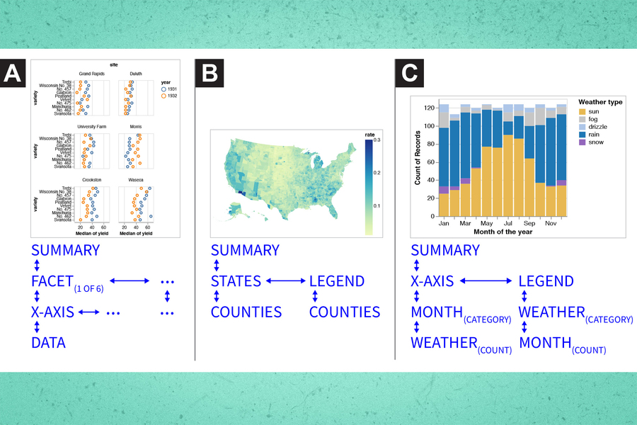
Making data visualization more accessible for blind and low-vision individuals(图)
盲人 低视力人士 数据可视化
2023/6/20
A comprehensive and automated machine-learning platform for nucleic acid and protein sequence analysis, prediction and visualization
棉花 纤维品质 QTL 遗传基因组
2024/4/16
UNCERTAINTY VISUALIZATION APPROACHES FOR 3D MODELS OF CASTLES RESTITUTED FROM ARCHEOLOGICAL KNOWLEDGE
Restitution Uncertainty visualization Archeological knowledge
2019/3/2
In the cultural heritage field, several specialists like archaeologists, architects, geomaticians, historians, etc. are used to work together. With the upcoming technologies allowing to capture effici...
DEVELOPMENT OF VIRTUAL REALITY APPLICATION FOR CULTURAL HERITAGE VISUALIZATION FROM MULTI-SOURCE 3D DATA
Virtual Reality Visualization Cultural heritage Multi-source data
2019/3/1
Immersive technologies like Virtual or Augmented Reality (VR/AR) are lately becoming more and more popular in wide range of scientific applications. These technologies provide the most immersive way t...
INTERACTIVE ONLINE VISUALIZATION OF COMPLEX 3D GEOMETRIES
3D visualization 3DHOP three.js navigation Cultural Heritage WebGL
2019/3/1
In the last decade 3D datasets of the Cultural Heritage field have become extremely rich and high detailed due to the evolution of the technologies they derive from. However, their online deployment, ...
Gradient Visualization for General Characterization in Profiling Attacks
Side Channel Analysis Profiling Attacks Deep Learning,
2018/12/19
Past few years have seen the emergence of Machine Learning and Deep Learning algorithms as promising tools for profiling attacks, especially Convolutional Neural Networks (CNN). The latters have indee...
APPLICATION OF VARIOUS OPEN SOURCE VISUALIZATION TOOLS FOR EFFECTIVE MINING OF INFORMATION FROM GEOSPATIAL PETROLEUM DATA
Open Source Geodata Visualization Data Mining Global Petroleum Statistics QGIS, R Sankey Maps
2019/2/27
This study emphasizes the use of various tools for visualizing geospatial data for facilitating information mining of the global petroleum reserves. In this paper, open-source data on global oil trade...
A MULTI-COMPONENT SYSTEM FOR DATA ACQUISITION AND VISUALIZATION IN THE GEOSCIENCES BASED ON UAVS, AUGMENTED AND VIRTUAL REALITY
Unmanned aerial systems virtual reality augmented reality mixed reality geovisualization education
2018/11/9
In this age of computer gaming, portable device video and high definition entertainment, students are exposed to sophisticated graphics and virtual reality every day. As a result, students arrive at u...
OPTIMIZED ORGANIZATION AND ADAPTIVE VISUALIZATION OF COMPLICATED MOUNTAIN DISASTER 3D SCENES FOR DIVERSE TERMINALS
Mountain Disaster 3D Scenes Adaptive Visualization
2018/11/9
Mountain disaster scenes usually contains various geographical entities, which are dynamic and complicated. Therefore, the construction of mountain disaster 3D scenes has great significance for disast...
DYNAMIC 3D VISUALIZATION OF FLOODS: CASE OF THE NETHERLANDS
Floods 3D visualization CityJSON Cesium 3D webglobe
2018/11/9
In this paper, we review state of the art 3D visualization technologies for floods and we focus on the Netherlands since it has a long history of dealing with floods and developing information technol...
VISUALIZATION AND ANALYSIS OF CELLULAR & TWITTER DATA USING QGIS
QGIS, Twitter feed, Cellular data, Origin Destination Matrices, Thematic maps
2018/11/8
The study is to understand individual presence and movement in Friuli Venezia Giulia region. It is important for tourism planning, hazard management, business marketing, implementing government lifeti...
ADDING 3D GIS VISUALIZATION AND NAVIGATION TO THE SPARQL QUERY LOOP
3D visualization, geospatial data, Linked Data, SPARQL, REPL, data analytics
2018/11/8
3D environments allow advanced spatial navigation and visualization, but have traditionally provided limited support for performing non-spatial data analysis operations like filtering, joining, and in...
INFORMATION EXTRACTION OF TOURIST GEOLOGICAL RESOURCES BASED ON 3D VISUALIZATION REMOTE SENSING IMAGE
Remote sensing image 3D visualization Tourism geological resources Information Extraction Investigation
2018/5/15
Tourism geological resources are of high value in admiration, scientific research and universal education, which need to be protected and rationally utilized. In the past, most of the remote sensing i...
RESEARCH ON VISUALIZATION OF GROUND LASER RADAR DATA BASED ON OSG
LiDAR Data Visualization OSG Point Cloud Triangulation Network Qt
2018/5/14
Three-dimensional (3D) laser scanning is a new advanced technology integrating light, machine, electricity, and computer technologies. It can conduct 3D scanning to the whole shape and form of space o...
COMBINING INDEPENDENT VISUALIZATION AND TRACKING SYSTEMS FOR AUGMENTED REALITY
augmented reality pose estimation tracking calibration visualization
2018/6/4
The basic requirement for the successful deployment of a mobile augmented reality application is a reliable tracking system with high accuracy. Recently, a helmet-based inside-out tracking system whic...


