
搜索结果: 16-30 共查到“Remote Sensing”相关记录1234条 . 查询时间(0.271 秒)
Research on the Temporal and Spatial Distributions of Standing Wood Carbon Storage Based on Remote Sensing Images and Local Models
remote sensing GWR MGWR TWR GTWR standing wood carbon storage
2023/12/6
Background and Objectives: It is important to understand the temporal and spatial distributions of standing wood carbon storage in forests to maintain ecological balance and forest dynamics. Such info...
Remote Sensing Estimation of Forest Aboveground Biomass Based on Lasso-SVR
aboveground biomass remote sensing estimation Lasso algorithm support vector regression model
2023/12/1
With the Lutou Forest Farm as the research area, the Lasso algorithm was used for characteristic selection, and the optimal combination of variables was input into the support vector regression (SVR) ...
Enhancing the Accuracy and Temporal Transferability of Irrigated Cropping Field Classification Using Optical Remote Sensing Imagery
irrigated field classification Landsat NDVI time series Gaussian mixture model interannual climate variability regional analysis
2023/12/1
Mapping irrigated areas using remotely sensed imagery has been widely applied to support agricultural water management; however, accuracy is often compromised by the in-field heterogeneity of and inte...
Stand Canopy Closure Estimation in Planted Forests Using a Geometric-Optical Model Based on Remote Sensing
canopy closure the GOST model fisheye camera photos transects LAI
2023/11/30
Canopy closure, which is the ratio of the vertical projection area of the crowns to the area of forest land, can indicate the growth and tending situation of a forest and is of great significance for ...

中国科学院地理科学与资源研究所莫兴国研究团队提出一个新的河道水位遥感反演方法新近在Remote Sensing of Environment 发表(图)
莫兴国 水位遥感 水文 水资源管理
2024/1/14
河道水位是洪水预报的关键变量,也是地表水资源供给能力的晴雨表。河道水位一般通过水文站实测,但由于全球水文站网密度稀疏,流域内存在大量的无河道水位观测断面,成为全流域精准防洪和水资源管理的硬件短板。测高卫星观测的水位数据可以覆盖全河道,这有力地提高了水位数据的空间代表能力。然而测高卫星要么空间分辨率太粗糙,无法识别小于80米的窄河道的水位;要么回访周期太长,无法探测河宽的关键时间变化节点。因此如何获...
南京农业大学农学院《Remote Sensing ofEnvironment》发表智慧农业团队“The relationship between wheat yield and sun-induced chlorophyll fluorescence from continuous measurements over the growing season”(图)
智慧农业 农作物产量;生育
2023/10/28
2023年来,南京农业大学农学院智慧农业团队利用日光诱导叶绿素荧光(SIF)估测产量进行了深入研究。研究结果2023年9月22日以“The relationship between wheat yield and sun-induced chlorophyll fluorescence from continuous measurements over the growing season”为题,...
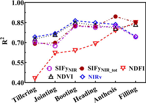
浙江农林大学省部共建亚热带森林培育国家重点实验室森林碳汇研究团队在《Remote Sensing of Environment》发表高水平论文(图)
SIF 植被指数 物候提取精度 竹林物候 时空格局制图
2024/3/5
近日,浙江农林大学省部共建亚热带森林培育国家重点实验室森林碳汇研究团队在遥感领域国际顶尖期刊《Remote Sensing of Environment》(中国科学院1区Top,IF=13.85)在线发表题为“Improving extraction phenology accuracy using SIF coupled with the vegetation index and mapping...
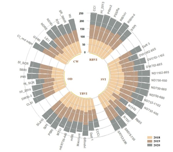
中国农业大学植物保护学院马占鸿教授团队在IEEE Transactions on Geoscience and Remote Sensing发表研究成果(图)
马占鸿 IEEE Transactions on Geoscience and Remote Sensing 小麦条锈病 遥感
2023/12/11
近日,中国农业大学植物保护学院植病流行与智慧植保实验室马占鸿教授团队在遥感领域国际权威期刊IEEE Transactions on Geoscience and Remote Sensing (TGRS)发表论文“Quantitative Estimation of Wheat Stripe Rust Disease Index Using Unmanned Aerial Vehicle Hype...
Academy of Mathematics and Systems Science, CAS Colloquia & Seminars:Optimization problem in remote sensing data processing
遥感 数据处理 优化问题
2023/5/4
In this talk, we will introduce some optimization problem in remote sensing data processing. The high dimensional characteristics of remote sensing data, especially hyperspectral data, will not only l...
南京农业大学农学院《Remote Sensing of Environment》发表智慧农业团队“A disease-specific spectral index tracks Magnaporthe oryzae infectionin paddy rice from ground to space”(图)
智慧农业 时空动态 遥感监测 稻瘟病
2023/10/28
2023年2月25日,农学院智慧农业团队在国际顶级遥感期刊《Remote Sensing of Environment》发表了题为“A disease-specific spectral index tracks Magnaporthe oryzae infectionin paddy rice from ground to space”的研究论文,报道了他们在多尺度稻叶瘟敏感光谱指数构建,以及小...
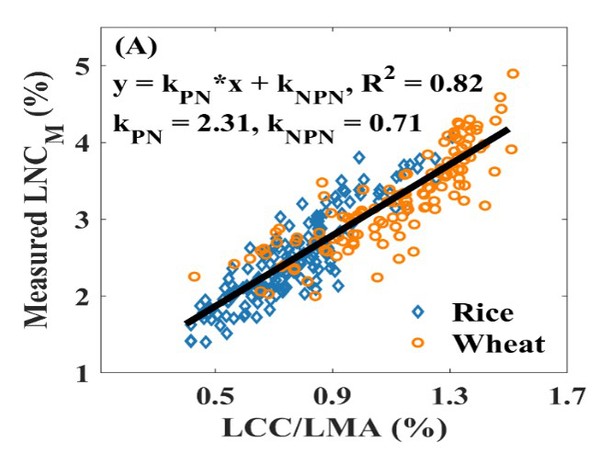
南京农业大学农学院《Remote Sensing of Environment》发表智慧农业团队“Estimating leaf nitrogen content by coupling a nitrogen allocation model with canopy reflectance”(图)
智慧农业 光谱监测 植物光合
2023/10/28
2022年11月1日,农学院智慧农业团队在国际顶级遥感期刊《Remote Sensing of Environment》发表了题为“Estimating leaf nitrogen content by coupling a nitrogen allocation model with canopy reflectance”的研究论文,报道了他们在冠层尺度氮含量光谱监测普适性模型构建方面的重要进展...

南京农业大学农学院《Remote Sensing of Environment》发表智慧农业团队“Assessing a soil-removed semi-empirical model for estimating leaf chlorophyll content”(图)
智慧农业 光谱监测 作物光合 氮素营养
2023/10/28
2022年10月7日,农学院智慧农业团队在国际顶级遥感期刊《Remote Sensing of Environment》发表了题为“Assessing a soil-removed semi-empirical model for estimating leaf chlorophyll content”的研究论文,报道了他们在冠层尺度叶片叶绿素含量光谱监测普适性模型构建和土壤影响消除方面的重要进展...

近日,浙江大学本科生科研训练项目(SRTP)“浮游植物层次构建与其海洋学意义研究”课题成员――光电科学与工程学院2019级本科生杨一辰、潘杭凯和郑德康,利用激光雷达在探测海洋浮游植物薄层方面的高效性,分析了浮游植物薄层的特征和形成机理。该成果有助于海洋激光雷达技术的应用研究,并加深对海洋浮游植物薄层的认识与理解。
研究成果以”Characteristics and Formation Condi...
实时监测生物量对农田管理、产量估测及粮食安全等具有重要意义。2022年3月9日,北京农业信息技术研究中心陈立平研究员、杨贵军研究员、李振海博士等团队的研究成果在国际期刊Remote Sensing of Environment(IF=10.164)在线发表了题为“ Comparison forbid transferability of thermal, temporal forbid pheno...
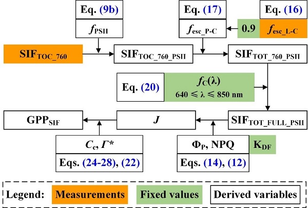
Remote Sensing of Environment刊发中国科学院水利部水土保持研究所吕肖良研究员团队日光诱导叶绿素荧光研究工作进展(图)
吕肖良 日光诱导 叶绿素荧光 SIF GPP
2022/6/8
近日,中国科学院水利部水土保持研究所吕肖良研究员团队以西北农林科技大学黄土高原土壤侵蚀与旱地农业国家重点实验室为第一单位在国际遥感领域顶级期刊Remote Sensing of Environment(G1期刊)发表了题为“Direct estimation of photosynthetic CO2 assimilation from solar-induced chlorophyll fluo...