
�������: 1-15 ���鵽��topographic����ؼ�¼210�� . ��ѯʱ��(0.296 ��)
�й����ʴ�ѧ��ѧ������չԺ��ι�* �ȣ���ԴѧԺ. Journal of Hydrology��2020��, Digital Elevation Models for topographic characterisation and flood flow modelling along low-gradient, terminal dryland rivers: A comparison of spaceborne datasets for the R��o Colorado, Bolivia��ͼ��
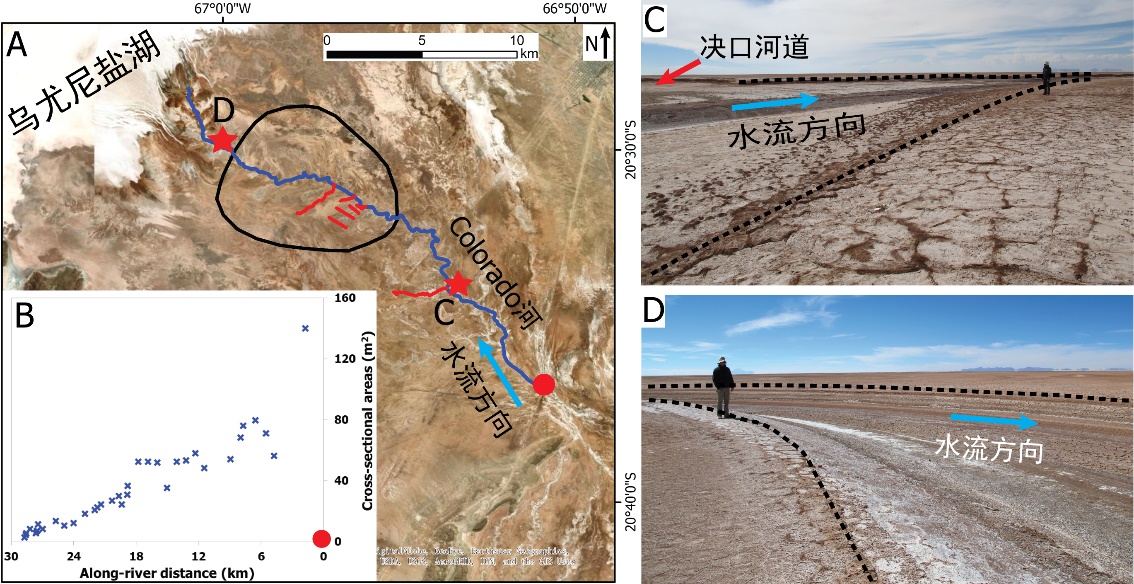
��ȷ���������ͣ���������ĩ�ˣ����Σ�ģ��ӵ�����ˮ������
2021/10/15
���գ�����֪���ڿ�Journal of Hydrology���߿������й����ʴ�ѧ��ԴѧԺ��ι⸱�����Ŷ���½������Ե����ĩ�˳�����ϵ�о������³ɹ�����Digital Elevation Models for topographic characterisation and flood flow modelling along low-gradient, terminal dryland rive...
STUDY ON SITE CONDITIONS BASED ON TOPOGRAPHIC SLOPE
DEM, Topographic Slope, Vs30, Site Conditions
2018/5/15
The travel-time averaged shear-wave velocity to a depth of 30m (Vs30) below the Earth��s surface is widely used to classify sites in many building codes. Vs30 is also used to estimate site classificati...
TOPOGRAPHIC FEATURES OF MALYY NARYN RIVER WATERSHED BASED ON DIFFERENT DATA
ZY3 DSM SRTM DEM ASTER GDEM Topographic Features Slop HI River Network Density River Network Discrepancy
2018/5/14
This paper researched the influence on the topographical characteristics of watersheds by setting different catchment area thresholds based on different data sets, namely ZY3 DSM, SRTM DEM and ASTER G...
FOREST TREE SPECIES DISTRIBUTION MAPPING USING LANDSAT SATELLITE IMAGERY AND TOPOGRAPHIC VARIABLES WITH THE MAXIMUM ENTROPY METHOD IN MONGOLIA
Tree species mapping Landsat imagery Maximum Entropy Terrain variable Mongolia
2016/11/30
Forest is a very important ecosystem and natural resource for living things. Based on forest inventories, government is able to make decisions to converse, improve and manage forests in a sustainable ...
INFLUENCE OF TOPOGRAPHIC AND HYDROGRAPHIC FACTORS ON THE SPATIAL DISTRIBUTION OF LEPTOSPIROSIS DISEASE IN SAO PAULO COUNTY,BRAZIL:AN APPROACH USING GEOSPATIAL TECHNIQUES AND GIS ANALYSIS
Spatial Analysis GIS Leptospirosis Disease Sao Paulo Brazil Environmental Variables
2016/11/30
Leptospirosis is a zoonosis caused by Leptospira genus bacteria. Rodents, especially Rattus norvegicus, are the most frequent hosts of this microorganism in the cities. The human transmission occurs b...
LANDSLIDES IDENTIFICATION USING AIRBORNE LASER SCANNING DATA DERIVED TOPOGRAPHIC TERRAIN ATTRIBUTES AND SUPPORT VECTOR MACHINE CLASSIFICATION
Airborne laser scanning support vector machine landslide mapping Pricncipal Component Analysis
2016/11/30
Since the availability of high-resolution Airborne Laser Scanning (ALS) data, substantial progress in geomorphological research, especially in landslide analysis, has been carried out. First and secon...
UPDATING NATIONAL TOPOGRAPHIC DATA BASE USING CHANGE DETECTION METHODS
NTDB (National topographic data base) Segmentation Classification DSM DTM
2016/11/23
The traditional method for updating a topographic database on a national scale is a complex process that requires human resources, time and the development of specialized procedures. In many National ...
ACCELERATION OF TOPOGRAPHIC MAP PRODUCTION USING SEMI-AUTOMATIC DTM FROM DSM RADAR DATA
Automatic DTM Classification Topographic Map
2016/11/23
Badan Informasi Geospasial (BIG) is government institution in Indonesia which is responsible to provide Topographic Map at several map scale. For medium map scale, e.g. 1:25.000 or 1:50.000, DSM from ...
INTEGRATED PROCESSING OF HIGH RESOLUTION TOPOGRAPHIC DATA FOR SOIL EROSION ASSESSMENT CONSIDERING DATA ACQUISITION SCHEMES AND SURFACE PROPERTIES
UAV photogrammetry TLS data fusion scan geometry surface roughness soil erosion
2016/11/11
Soil erosion is a decisive earth surface process strongly influencing the fertility of arable land. Several options exist to detect soil erosion at the scale of large field plots (here 600 m2), which ...
REINVENTING THE NATIONAL TOPOGRAPHIC DATABASE
Topographic Mapping Core Data Spatial Data Infrastructure 3D 4D Persistent Identifiers
2016/11/8
The National Land Survey (NLS) has had a digital topographic database (TDB) since 1992. Many of its features are based on the Basic Map created by M. Kajamaa in 1947, mapping first completed in 1977. ...
THE STATUS OF TOPOGRAPHIC MAPPING IN THE WORLD A UNGGIM�CISPRS PROJECT 2012�C2015
Topographic mapping, Global status of mapping
2016/11/8
In December 2011, UNGGIM initiated a cooperative project with ISPRS to resume the former UN Secretariat studies on the status of topographic mapping in the world, conducted between 1968 and 1986. Afte...
THE TOPOGRAPHIC DATA DELUGE �C COLLECTING AND MAINTAINING DATA IN A 21ST CENTURY MAPPING AGENCY
Mobile mapping UAVs Oblique Imagery Terrestrial Laser Scanning
2016/11/8
In the last few years, the number of sensors and data collection systems available to a mapping agency has grown considerably. In the field, in addition to total stations measuring position, angles an...
TOPOGRAPHIC MAPPING OF PLUTO AND CHARON USING NEW HORIZONS DATA
Pluto Charon Topographic Mapping Spatial Databases
2016/11/8
New Horizons 2015 flyby of the Pluto system has resulted in high-resolution topographic maps of Pluto and Charon, the most distant objects so mapped. DEM��s over ~30% of each object were produced at 10...
MAPPING OF INNER AND OUTER CELESTIAL BODIES USING NEW GLOBAL AND LOCAL TOPOGRAPHIC DATA DERIVED FROM PHOTOGRAMMETRIC IMAGE PROCESSING
Planetary cartography DEM geomorphology study Phobos the Moon Mercury Ganymede and Enceladus
2016/11/8
New estimation of fundamental geodetic parameters and global and local topography of planets and satellites provide basic coordinate systems for mapping as well as opportunities for studies of process...
THE USE OF MULTIPLE DATA SOURCES IN THE PROCESS OF TOPOGRAPHIC MAPS UPDATING
LiDAR DTM Hydrohraphy Satellite images
2016/11/8
The methods used in the process of updating maps have evolved and become more complex, especially upon the development of the digital technology. At the same time, the development of technology has le...
�й��о����������а�-��
- ���ڼ���...
�й�ѧ���ڿ����а�-��
- ���ڼ���...
�����ѧ���л������а�-��
- ���ڼ���...
�й���ѧ���а�-��
- ���ڼ���...
�ˡ���-ƪ
- ���ڼ���...
�Ρ���-ƪ
- ���ڼ���...
��������-ƪ
- ���ڼ���...
�������� -ƪ
- ���ڼ���...
֪ʶҪ��-ƪ
- ���ڼ���...
���ʶ�̬-ƪ
- ���ڼ���...
��������-ƪ
- ���ڼ���...
ѧ��ָ��-ƪ
- ���ڼ���...
ѧ��վ��-ƪ
- ���ڼ���...