搜索结果: 1-15 共查到“deforestation”相关记录33条 . 查询时间(0.072 秒)

A study by NSF-funded scientists Andy MacDonald at UC Santa Barbara and Erin Mordecai at Stanford found a direct relationship between deforestation in the Amazon and the transmissi...

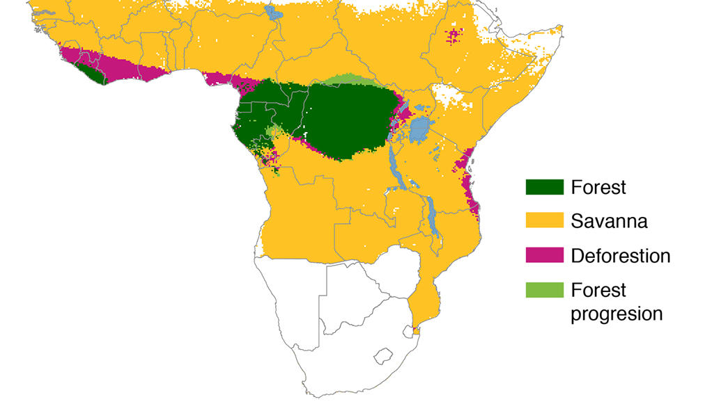
African Deforestation Not As Great As Feared,Yale Research Shows(图)
African Deforestation Not As Great As Feared Yale
2017/12/19
The loss of forests in Africa in the past century is substantially less than previously estimated, an analysis of historical records and paleontology evidence by Yale researchers shows.Previous estima...
Stanford study explores risk of deforestation as agriculture expands in Africa
Stanford explores risk deforestation agriculture expands Africa
2017/4/27
Next time you bite into a chocolate bar, think of Africa. The continent produces nearly 70 percent of the world’s cocoa, a growing output that requires carving more than 325,000 acres of new farmland ...
The influence of deforestation and anthropogenic activities on runoff generation
rainfall-runoff model forest sediment Iand use Talar watershed Iran
2018/3/6
In recent decades, due to rapid human population increases and in its results, destructive effects of anthropogenic
activities on natural resources have become a great challenge. Land use and vegetat...
DEFORESTATION ALONG THE MAYA MOUNTAIN MASSIF BELIZE-GUATEMALA BORDER
Deforestation Transboundry Maya Mountain Massif Protected Areas Biodiversity Belize
2016/11/30
In recent years trans-boundary incursions from Petén, Guatemala into Belize’s Maya Mountain Massif (MMM) have increased. The incursions are rapidly degrading cultural and natural resources in Belize’s...
EVALUATION OF ANNUAL MODIS PTC DATA FOR DEFORESTATION AND FOREST DEGRADATION ANALYSIS
MODIS VCF Percent Tree Cover (PTC) deforestation
2016/7/8
Anthropogenic land-cover change, e.g. deforestation and forest degradation cause carbon emissions. To estimate deforestation and forest degradation, it is important to have reliable data on forest cov...
AMAZON DEFORESTATION MONITORING SYSTEM WITH ALOS SAR COMPLEMENTARY DATA
Environmental monitoring SAR Radar Real-Time
2015/12/28
Deforestation monitoring for the Brazilian Amazon has been carried on by INPE since 1988, under the PRODES program, and recently, the DETER was created for faster response. The data from both programs...
ASSESSING MODIFIABLE AREAL UNIT PROBLEM IN THE ANALYSIS OF DEFORESTATION DRIVERS USING REMOTE SENSING AND CENSUS DATA
Modifiable areal unit problem Scale Aggregation Spatial analysis Deforestation drivers
2015/9/21
In order to identify drivers of land use / land cover change (LUCC), the rate of change is often compared with environmental and socio-economic variables such as slope, soil suitability or population ...
Predicting the Location of Deforestation in North Thailand: The Role of Roads and Protected Areas
North Thailand Roads and Protected Areas
2015/9/18
Predicting the Location of Deforestation in North Thailand: The Role of Roads and Protected Areas。
We estimate an equilibrium model
of land clearing to study the impacts of roads and
population on deforestation in Thailand between
1976 and 1989. Population pressures were more
important in the N...
OBJECT BASED CLASSIFICATION OF L-BAND SAR DATA FOR THE DELINEATION OF FOREST COVER MAPS AND THE DETECTION OF DEFORESTATION
JERS ALOS L-band Forest Cover Forest Cover Change Kyoto ARD Object Based Classification
2015/8/19
This paper assesses the feasibility of forest cover mapping and the delineation of deforestation using Japanese Earth Resource Satellite (JERS-1) Synthetic Aperture Radar (SAR) data. The assessment is...
Policy-making and programme formulation in regard to population, deforestation and other environmental problems in the humid tropics will have to be done in a context of uncertainty. Many facts are un...
BRIDGING REMOTE SENSING ANALYSTS AND DECISION-MAKERS; THE SUPPORT OF AGGREGATE-MOSAIC THEORY TO MONITOR TROPICAL DEFORESTATION
Theory Segmentation Forestry Land Cover Mapping Vegetation heterogeneity
2015/6/1
The land cover mosaic (LCM) classification concept, which is based on the aggregate-mosaic theory, improves geo-information on tropical deforestation for decision-makers. Land cover mosaics are spatia...
Deforestation modelling using logistic regression and GIS
manmade areas physiographic factors
2015/5/18
A methodology has been used by means of which modellers and planners can quantify the certainty in
predicting the location of deforestation. Geographic information system and logistic regression ana...
CHANGES IN THE LAND COVER AND LAND USE OF THE ITACAIúNAS RIVER WATERSHED, ARC OF DEFORESTATION, CARAJáS, SOUTHEASTERN AMAZON
Landsat, change detection, object based image analysis
2015/5/7
Human actions are changing the Amazon’s landscape by clearing tropical forest and replacing it mainly by pasturelands. The focus of this work is to assess the changes in the Itacaiúnas River watersh...

