
搜索结果: 1-15 共查到“Digital Elevation”相关记录90条 . 查询时间(0.147 秒)
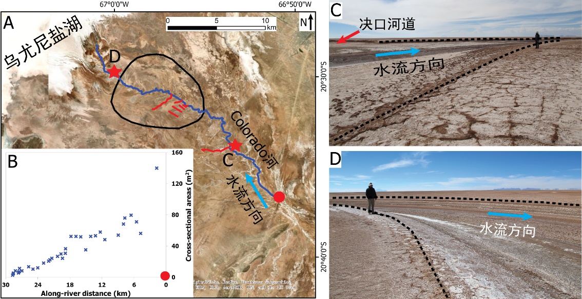
中国地质大学科学技术发展院李嘉光* 等,资源学院. Journal of Hydrology(2020), Digital Elevation Models for topographic characterisation and flood flow modelling along low-gradient, terminal dryland rivers: A comparison of spaceborne datasets for the Río Colorado, Bolivia(图)
精确表征;极低;缓河流;末端;地形;模拟河道;洪水;漫溢
2021/10/15
近日,国际知名期刊Journal of Hydrology在线刊发了中国地质大学资源学院李嘉光副教授团队在陆相湖盆边缘河流末端沉积体系研究的最新成果――Digital Elevation Models for topographic characterisation and flood flow modelling along low-gradient, terminal dryland rive...
SUBAQUATIC DIGITAL ELEVATION MODELS FROM UAV-IMAGERY
UAV, DEM underwater multi-media bundle-adjustment
2018/6/4
The paper presents an approach for the generation of digital elevation models (DEMs) of underwater areas from aerial images. Standard software-products do not provide the possibility to measure correc...
VERTICAL ACCURACY COMPARISON OF DIGITAL ELEVATION MODEL FROM LIDAR AND MULTITEMPORAL SATELLITE IMAGERY
Vertical Accuracy LiDAR DEM Multitemporal Stereo Satellite Imagery DEM
2017/7/13
Digital elevation model serves to illustrate the appearance of the earth's surface. DEM can be produced from a wide variety of data sources including from radar data, LiDAR data, and stereo satellite ...
VEGETATION COVER MAPPING BASED ON REMOTE SENSING AND DIGITAL ELEVATION MODEL DATA
Geographic Information System (GIS) Remote Sensing (RS) Digital Elevation Model (DEM) Vegetation Mapping
2016/11/30
An algorithm of forest cover mapping based on combined GIS-based analysis of multi-band satellite imagery, digital elevation model, and ground truth data was developed. Using the classification princi...
DETERMINING THE SUITABILITY OF DIFFERENT DIGITAL ELEVATION MODELS AND SATELLITE IMAGES FOR FANCY MAPS. AN EXAMPLE OF CYPRUS
Fancy map Image DEM Relief shading hillshading image merge color composite
2016/11/8
The article describes the possibility of developing an overall map of the selected area on the basis of publicly available data. Such a map would take the form designed by the author with the colors t...
VALIDATION OF THE ASTER GLOBAL DIGITAL ELEVATION MODEL VERSION 3 OVER THE CONTERMINOUS UNITED STATES
Accuracy DEM/DTM Comparison Geodesy Global-Environmental-Databases Land Cover Mapping Satellite
2016/11/8
The ASTER Global Digital Elevation Model Version 3 (GDEM v3) was evaluated over the conterminous United States in a manner similar to the validation conducted for the original GDEM Version 1 (v1) in 2...
OPEN-SOURCE DIGITAL ELEVATION MODEL (DEMs) EVALUATION WITH GPS AND LiDAR DATA
Digital Elevation Model inundation mapping vertical accuracy LiDAR scale factor coastal inundation risk assessment
2016/10/14
Advanced Spaceborne Thermal Emission and Reflection Radiometer-Global Digital Elevation Model (ASTER GDEM), Shuttle Radar Topography Mission (SRTM), and Global Multi-resolution Terrain Elevation Data ...
NSF,NGA release first unclassified digital elevation models of Alaska
NSF NGA first unclassified digital elevation models Alaska
2016/9/12
The National Science Foundation (NSF) and the National Geospatial-Intelligence Agency (NGA) have publicly released new three-dimensional topographic maps of Alaska in support of a White House Arctic i...
PREPARATION OF THE DIGITAL ELEVATION MODEL FOR ORTHOPHOTO CR PRODUCTION
Airborne Laser Scanning Digital Elevation Model Orthorectification Surface Modelling True Orthophoto
2016/7/27
The Orthophoto CR is produced in co-operation with the Land Survey Office and the Military Geographical and Hydrometeorological Office. The product serves to ensure a defence of the state, integrated ...
THE NEED OF NESTED GRIDS FOR AERIAL AND SATELLITE IMAGES AND DIGITAL ELEVATION MODELS
Orthoimages DEM Geographic Grid
2016/7/8
Usual workflows for production, archiving, dissemination and use of Earth observation images (both aerial and from remote sensing satellites) pose big interoperability problems, as for example: non-al...
EVALUATION DIGITAL ELEVATION MODEL GENERATED BY SYNTHETIC APERTURE RADAR DATA
Interferometry RADAR Digital Elevation Model European Space Agency Sentinel1-A Interferometry Wide Swath Synthetic Aperture Radar SAR DEM
2016/7/4
Digital elevation model, showing the physical and topographical situation of the earth, is defined a tree-dimensional digital model obtained from the elevation of the surface by using of selected an a...
Accuracy of Digital Elevation Model according to spatial resolution
Accuracy Digital Elevation Model according spatial resolution
2016/5/23
Digital Elevation Model (DEM) is indispensable for many analyses such as topographic feature extraction, runoff analysis, slope stability analysis and so on. Beforehand such analyses, accuracy of DEM ...
Triangulated Digital Elevation Model: definition of a new representation
DEM structure DEM generation TIN regular network DEM quality criterion
2016/5/23
In this paper we discuss about the need of a new DEM representation for simulation in GIS. This leads us to analyse through quality criteria the current DEM structures. Then we propose a new DEM repre...
The scheme for the database building and updating of 1:10000 Digital Elevation Models
Geospatial data DEM Photogrammetric sampling Cartographic digitisation Specification
2016/5/20
The National Bureau of Surveying & Mapping of China has planned to speed up its development of spatial data infrastructure (SDI) in the coming few years. This SDI consists of four types of digital pro...
Mosaicking of Digital Elevation Models derived by SAR interferometry
Mosaicking Digital Elevation Models derived SAR interferometry
2016/5/20
In the framework of the Shuttle Radar Topography Mapper (SRTM) Mission the generation of high-quality Digital Elevation Models (DEMs) with global coverage of the earth's surface is envisaged. In this ...