
搜索结果: 1-15 共查到“地图制图技术 Web”相关记录84条 . 查询时间(0.299 秒)
DEVELOPMENT OF WEB BASED HIMALAYAN GLACIER INFORMATION SYSTEM USING OPEN SOURCE
Glacier Himalaya Natural Resources OGC Information System
2018/11/8
Systematic inventory of glaciers is required for a variety of applications needed for the comprehensive development of the Himalayan region such as: a) disaster warning, b) estimation of irrigation po...
MIGRATION OF DIGITAL CARTOGRAPHY TO CITYGML; A WEB-BASED TOOL FOR SUPPORTING SIMPLE ETL PROCEDURES
CityGML GIS Extract Transform and Load ETL, Open Source
2018/11/9
Digital cartography is notably produced in all countries, in different scales and formats. Latest cartographic production aims at creating 3D objects with topological consistency and rich information ...
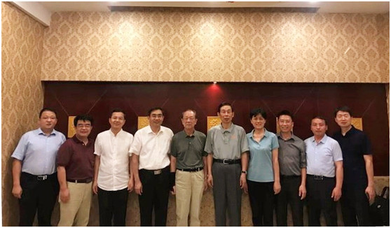
河南大学举办全国高校《Web GIS原理与技术》课程研讨会(图)
河南大学 高校 Web GIS原理与技术 课程研讨会
2018/8/13
2018年8月1日-4日,全国高校《Web GIS原理与技术》课程研讨会在我校环境与规划学院二楼报告厅举行。会议由Esri中国、高等教育出版社、河南大学联合主办,河南大学环境与规划学院承办。著名地理信息科学专家孙九林院士、王家耀院士,美国环境系统研究所(Esri)项目主管、国际华人地理信息科学协会(CPGIS)前任主席付品德教授,Esri中国区副总裁、首席咨询专家蔡晓兵高级工程师,技术专家蔡京晶高...
THE XII CENTURY TOWERS, A BENCHMARK OF THE ROME COUNTRYSIDE ALMOST CANCELLED: THE SAFEGUARD PLAN BY LOW COST UAV AND TERRESTRIAL DSM PHOTOGRAMMETRY SURVEYING AND 3D WEB GIS APPLICATIONS
XII century towers Rome Mid-Age countryside Cultural Heritage preservation close-range photogrammetry UAV photogrammetry integrated survey low-cost action camera GPS Web GIS 2D and 3D
2018/3/5
This is the consequence of the phenomenon identified with the “Incasalamento” neologism, described in depth in the following paper, intended as the general process of expansion of the urban society in...
第五届在线地图,地学处理与服务国际研讨会(5th International Workshop on Web Mapping,Geoprocessing and Services)
第五届 在线地图,地学处理与服务 国际研讨会
2017/4/26
WebMGS is an important event in the field of web-based GIS, which emphasizes a diverse range of topics related to new web-based developments of geospatial theories, technologies and solutions. The Web...
The 5th International Workshop on Web Mapping,`Geoprocessing and Services
The 5th International Workshop Web Mapping,Geoprocessing and Services
2017/3/10
WebMGS is an important event in the field of web-based GIS, which emphasizes a diverse range of topics related to new web-based developments of geospatial theories, technologies and solutions. The Web...
New implementation of OGC Web Processing Service in Python programming language.PyWPS-4 and issues we are facing with processing of large raster data using OGC WPS
OGC Web Processing Service OGC WPS PyWPS Open Source Software Free Software FOSS4G OSGeo Python Server
2016/11/24
The OGC® Web Processing Service (WPS) Interface Standard provides rules for standardizing inputs and outputs (requests and responses) for geospatial processing services, such as polygon overlay. ...
3D urban GIS on the WEB: Data structuring and visualization
3D urban GIS WEB Data structuring visualization
2016/5/23
The maintenance, visualization and query of 3D urban data has always been problematic due to the complexity of geometry, diversity of attribute information, large amounts of data, demanded comprehensi...
DESIGN AND IMPLEMENTATION OF A COASTAL WEB ATLAS (CWA) FOR THE INTEGRATED COASTAL ZONE MANAGEMENT OF JIANGSU,CHINA
Coastal Web based GIS Mapping Visualization
2015/12/29
In Section 1, the background of the research is introduced. The Jiangsu Coastal Web Atlas is a project that has the ambitious goal of being a useful resource for the various audiences that make up the...
Web-GIS Based Collaboration Environment Using Scientific Data of the Moon
Exploration GIS Internt/Web Mapping Analysis Database Planetary
2015/12/18
On 14 September 2007, the first Japanese large-scaled lunar explorer “Kaguya” (SELENE), developed by JAXA (Japan Aerospace and Exploration Agency) was launched. Kaguya successfully reached moon in Oct...
Supporting Mobile GIS Applications by Geospatial Web Services
Location Based Services Mobile GIS Data Management Interoperability
2015/12/17
Spatial data infrastructures (SDI) providing geospatial web services as well as mobile GIS software become more and more popular. Fields like disaster management require the use of SDIs as well as of ...
Web 2.0 Based Satellite Images Search through Mash-Up
Mash-Up Web 2.0 Satellite Images Search System
2015/12/17
To maximize the utility of satellite image materials, those who gain access to such for the first time or who lack the necessary knowledge as well as the existing users should be able to access such m...
WebMozis - Web-Based and Mobile Zoo Information System - a Case Study for the City of Osnabrueck
Spatial Database Open Source Pocket PC Web Mapping GIS
2015/12/17
The use of modern electronic media offers new ways of (environmental) knowledge transfer. All kind of information can be made quickly available as well as queryable and can be processed individually.T...
Design and Development of Emergency Response Geographic Information Platform Based on Web Service
Web Service GIS Emergency Web Based Integration
2015/12/17
Emergency management/Emergency service is a compelling domain for applying GIS Web Service. GIS Web Service expands the further development of GIS. A Web service is described using XML-standards like ...
SUAS Mapserver -an Open Source Framework for Extended Web Map Services
Internet/Web Mapping Services SVG Interoperability Spatial Infrastructures Standards SVGT
2015/12/16
The Web Map Server Implementation Specification (WMS), originally developed and published by the Open Geospatial Consortium, was finally adopted by ISO as an international standard. According to this ...