
�������: 1-15 ���鵽����ѧ crop����ؼ�¼113�� . ��ѯʱ��(0.231 ��)
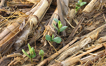
No-till agriculture increases crop yields, environmental gains over long haul��ͼ��
No-till agriculture increases crop yields environmental gains long haul
2020/5/29
A study in Global Change Biology clearly demonstrates significant benefit to the environment and to crop yield for farmers practicing no-till versus tilled agriculture consistently...
THE COMBINATION OF UAV SURVEY AND LANDSAT IMAGERY FOR MONITORING OF CROP VIGOR IN PRECISION AGRICULTURE
Unmanned aerial vehicle satellite remote sensing vegetation indices winter wheat site specific crop management
2016/12/1
Mapping of the with-in field variability of crop vigor has a long tradition with a success rate ranging from medium to high depending on the local conditions of the study. Information about the develo...
COMBINED ANALYSIS OF SENTINEL-1 AND RAPIDEYE DATA FOR IMPROVED CROP TYPE CLASSIFICATION:AN EARLY SEASON APPROACH FOR RAPESEED AND CEREALS
crop type mapping Sentinel-1 RapidEye agriculture Support Vector Machine Maximum Likelihood
2016/12/1
Timely availability of crop acreage estimation is crucial for maintaining economic and ecological sustainability or modelling purposes. Remote sensing data has proven to be a reliable source for crop ...
RICE YIELD ESTIMATION THROUGH ASSIMILATING SATELLITE DATA INTO A CROP SIMUMLATION MODEL
Data assimilation remote sensing crop simulation model rice yield
2016/12/1
Rice is globally the most important food crop, feeding approximately half of the world��s population, especially in Asia where around half of the world��s poorest people live. Thus, advanced spatiotempo...
MONITORING OF IN-FIELD VARIABILITY FOR SITE SPECIFIC CROP MANAGEMENT THROUGH OPEN GEOSPATIAL INFORMATION
satellite images location-based services environmental monitoring open data cloud computing
2016/12/1
The agricultural sector is in a unique position due to its strategic importance around the world. It is crucial for both citizens (consumers) and the economy (both regional and global), which, ideally...
TIME SERIES ANALYSIS OF REMOTE SENSING OBSERVATIONS FOR CITRUS CROP GROWTH STAGE AND EVAPOTRANSPIRATION ESTIMATION
Time series Landsat Citrus crop Crop growth stage Evapotranspiration estimation Crop water requirement
2016/12/1
Satellite based earth observation (EO) platforms have proved capability to spatio-temporally monitor changes on the earth's surface. Long term satellite missions have provided huge repository of optic...
CROP SPECIES RECOGNITION AND DISCRIMINATION PADDY-RICE-GROWINGFIELDS FROM REAPED-FIELDS BY THE RADAR VEGETATION INDEX (RVI) OF ALOS-2/PALSAR2
radar vegetation index RVI ALOS-2 PALSAR2 crop biomass rice paddy fields
2016/12/1
The Japanese ALOS-2 satellite was launched on May 24th, 2014. It has the L-band SAR, PALSAR-2. Kim,Y. and van Zyl, J.J. proposed a kind of Radar Vegetation Index (RVI) as RVI = 8 * ��0hv / (��0hh + ��0vv...
USING LANDSAT 8 IMAGE TIME SERIES FOR CROP MAPPING IN A REGION OF CERRADO,BRAZIL
Crop mapping Landsat Time series Random Forest algorithm
2016/12/1
The objective of this research is to classify agricultural land use in a region of the Cerrado (Brazilian Savanna) biome using a time series of Enhanced Vegetation Index (EVI) from Landsat 8 OLI. Phen...
RICE CROP MAPPING USING SENTINEL-1A PHENOLOGICAL METRICS
Sentinel-1A crop phenology rice crop mapping Mekong Delta
2016/12/1
Rice is the most important food crop in Vietnam, providing food more than 90 million people and is considered as an essential source of income for majority of rural populations. Monitoring rice-growin...
POTENTIAL OF MULTITEMPORAL TANDEM-X DERIVED CROP SURFACE MODELS FOR MAIZE GROWTH MONITORING
SAR Interferometry Agriculture Maize Monitoring TanDEM-X SAR Crop Heights Radar Remote Sensing
2016/11/24
In this study, first results of retrieving plant heights of maize fields from multitemporal TanDEM-X images are shown. Three TanDEM-X dual polarization spotlight acquisitions were taken over a rural a...
A METHOD TO ESTIMATE TEMPORAL INTERACTION IN A CONDITIONAL RANDOM FIELD BASED APPROACH FOR CROP RECOGNITION
Conditional Random Fields Crop Recognition Multitemporal Image Analysis
2016/11/23
This paper presents a method to estimate the temporal interaction in a Conditional Random Field (CRF) based approach for crop recognition from multitemporal remote sensing image sequences. This approa...
EVALUATING DENSE 3D RECONSTRUCTION SOFTWARE PACKAGES FOR OBLIQUE MONITORING OF CROP CANOPY SURFACE
structure-from-motion csm crop surface monitoring 3D oblique vegetation monitoring comparison
2016/11/11
Crop Surface Models (CSMs) are 2.5D raster surfaces representing absolute plant canopy height. Using multiple CMSs generated from data acquired at multiple time steps, a crop surface monitoring is ena...
MULTI-TEMPORAL CROP SURFACE MODELS COMBINED WITH THE RGB VEGETATION INDEX FROM UAV-BASED IMAGES FOR FORAGE MONITORING IN GRASSLAND
Precision Agriculture Grassland UAV Crop Surface Model Structure from Motion RGBVI
2016/7/5
Remote sensing of crop biomass is important in regard to precision agriculture, which aims to improve nutrient use efficiency and to develop better stress and disease management. In this study, multi-...
UAV MULTISPECTRAL SURVEY TO MAP SOIL AND CROP FOR PRECISION FARMING APPLICATIONS
UAV multispectral images DEM orthophoto NDVI precision farming soil and crop characterization
2016/7/5
New sensors mounted on UAV and optimal procedures for survey, data acquisition and analysis are continuously developed and tested for applications in precision farming. Procedures to integrate multisp...
Multi-temporal Classification for Crop Discrimination using TerraSAR �C X Spotlight images
Multi-temporal Land-cover classification crop calendar speckle filtering
2016/1/25
Within the past years investigations have been carried out on the usefulness of ENVISAT ASAR dual polarimetric data for
environmental mapping of agricultural areas. The performance of such approach ...
�й��о����������а�-��
- ���ڼ���...
�й�ѧ���ڿ����а�-��
- ���ڼ���...
�����ѧ���л������а�-��
- ���ڼ���...
�й���ѧ���а�-��
- ���ڼ���...
�ˡ���-ƪ
- ���ڼ���...
�Ρ���-ƪ
- ���ڼ���...
��������-ƪ
- ���ڼ���...
�������� -ƪ
- ���ڼ���...
֪ʶҪ��-ƪ
- ���ڼ���...
���ʶ�̬-ƪ
- ���ڼ���...
��������-ƪ
- ���ڼ���...
ѧ��ָ��-ƪ
- ���ڼ���...
ѧ��վ��-ƪ
- ���ڼ���...