
搜索结果: 1-15 共查到“工学 cloud”相关记录246条 . 查询时间(0.089 秒)
American Nuclear Society conferences always showcase the latest in nuclear, but one of the biggest attractions at this past November’s Winter Conference and Expo in Washington, D.C., was tech that is ...

Today, the Harvard University Data Science Initiative announced the AWS Impact Computing Project at the HDSI, a collaboration with Amazon Web Services (AWS) aimed at reimagining data science to identi...

2020年1月8日,华为云年度峰会在北京钓鱼台国宾馆召开,我校软件学院院长、国家示范性软件学院联盟理事长卢苇教授受邀参加颁奖礼,北京交通大学软件学院作为高校唯一代表,荣获华为 “Cloud for Good大奖”。会上卢苇院长做了《产教融合,知行合一》峰会报告,分享了云计算、人工智能、5G等新一代信息技术迅速发展时代,高校结合“新工科”建设的要求,如何加大产学合作的力度,构建多学科交叉的复合型人才...
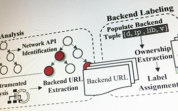
Smartphone apps may connect to vulnerable backend cloud servers(图)
Smartphone apps connect vulnerable backend cloud servers
2019/10/21
Cybersecurity researchers have discovered vulnerabilities in the backend systems that feed content and advertising to smartphone applications, potentially exposing users' personal information.In resul...
AUTOMATED DETECTION AND LAYOUT REGULARIZATION OF SIMILAR FEATURES IN INDOOR POINT CLOUD
Layout regularization Pattern detection Point cloud analysis Indoor modeling
2019/3/4
Automated identification of high-level structures in unorganized point cloud of indoor spaces Indoor space is an important aspect of scene analysis that provides essential information for many applica...
COMPARISON WITH ACCURACY OF TERRESTRIAL LASER SCANNER BY USING POINT CLOUD ALIGNED WITH SHAPE MATCHING AND BEST FITTING METHODS
laser scanning time of flight phase shift shape matching natural distributions Ostia
2019/3/4
Recently operation systems of laser scanning have been obviously improved; for instance shape matching has been equipped with software on a post processing stage so measurement without any targets is ...
POINT CLOUD SEGMENTATION AND SEMANTIC ANNOTATION AIDED BY GIS DATA FOR HERITAGE COMPLEXES
Point Cloud Segmentation Semantic GIS Heritage Complex Automation
2019/3/4
Point cloud segmentation is an important first step in categorising a raw point cloud data. This step is necessary in order to better manage the data and generate other derivative products, e.g. 3D GI...
AUTOMATING THE VERIFICATION OF HERITAGE BUILDING INFORMATION MODELS CREATED FROM POINT CLOUD DATA
3D analysis as-built BIM model checking point clouds deviations walls
2019/3/2
The use of remote sensors to acquire metric information for building information modelling (BIM) of heritage buildings is now common. Problematically, the creation of models from that information is s...
3D CITYGML BUILDING MODELLING FROM LIDAR POINT CLOUD DATA
LiDAR point cloud, CityGML LoD1 LoD Smart Cities D building model
2019/2/27
With recent government initiatives for smart cities, 3D virtual city models are in demand for managing and monitoring the urban infrastructure. 3D building models forms an important component of 3D vi...
AUTOMATED BUILDING DETECTION USING RANSAC FROM CLASSIFIED LIDAR POINT CLOUD DATA
LiDAR RANSAC Building Detection Plane Detection Python LAS Point Cloud
2018/11/8
For the past 10 years, the Philippines has seen and experienced the growing force of different natural disasters and because of this the Philippine governement started an initiative to use LiDAR techn...
COMPARING THE PERFORMANCE OF POINT CLOUD REGISTRATION METHODS FOR LANDSLIDE MONITORING USING MOBILE LASER SCANNING DATA
point clouds, registration methods landslide monitoring mobile laser scanning deviation maps
2018/11/8
The aim of the research is to evaluate the performance of the point cloud registration methods using mobile laser scanning data. The point cloud registration methods involved in this research are matc...
COMBINED VISUAL EXPLORATION OF 2D GROUND RADAR AND 3D POINT CLOUD DATA FOR ROAD ENVIRONMENTS
Ground Penetrating Radar 3D Point Cloud Infrastructure Maintenance
2018/11/9
Ground-penetrating 2D radar scans are captured in road environments for examination of pavement condition and below-ground variations such as lowerings and developing pot-holes. 3D point clouds captur...
SEGMENTATION OF 3D PHOTOGRAMMETRIC POINT CLOUD FOR 3D BUILDING MODELING
point clouds aerial photogrammetry segmentation classification 3D building reconstruction
2018/11/9
3D city modeling has become important over the last decades as these models are being used in different studies including, energy evaluation, visibility analysis, 3D cadastre, urban planning, change d...
INTEGRATION OF TREE DATABASE DERIVED FROM SATELLITE IMAGERY AND LIDAR POINT CLOUD DATA
Tree Crown Identification and Delineation Canopy Height Model Lidar Point Cloud Camera Model
2018/11/9
3D tree database provides essential information of tree species abundance, spatial distribution and tree height for forest mapping, sustainable urban planning and 3D city modelling. Fusion of passive ...
AUTOMATED BUILDING DETECTION IN DENSE POINT CLOUD AND UPDATE OF OPEN SOURCE DATA BASES
Dense matching, Building detection Classification Digital Terrain Model openstreetmap point cloud
2018/11/9
In this paper a method of detecting buildings in dense populated city areas using a three-dimensional model, produced by aerial images, is described. Further to the detection of the outline of the bui...