
�������: 1-15 ���鵽������ѧ Analysis����ؼ�¼182�� . ��ѯʱ��(0.36 ��)
��ɭ,�����* ����ԴѧԺ������������Դ�������ص�ʵ����. AAPG Bulletin, 2019. Seismic-based identification and stage analysis of overlapped compound sedimentary units in rifted lacustrine basins: An example from the Bozhong sag, Bohai Bay Basin, China
��ά���������ݣ���������̽
2021/10/20
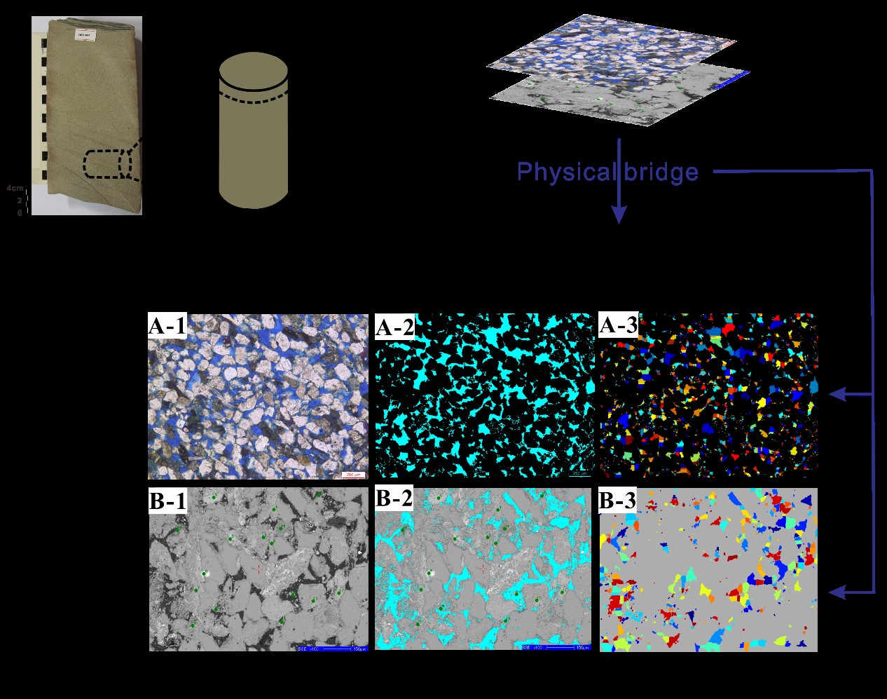
���գ��й����ʴ�ѧ��ԴѧԺ����ν����Ŷ��ڹ��ʶ���ʯ�͵����ڿ���AAPG Bulletin���Ͽ����о��ɹ���ϵͳ�����˻�����ά�������ϵ�½����ݺ��踴�ϳ�����ʶ���ڴλ��ַ��������Բ�������ض�Ӫ����ͱ�״��������Ϊʵ����������������Ϊָ������ϸ�����˱�״���������ڴε�����ṹ��ƽ��չ����̬���ؽ����������ݻ����̡��о��ɹ���½����ݺ��������پ����������㾫ϸ�̻���������Ȧ�����۾�����Ҫ����...
�й����ʴ�ѧ��ѧ������չԺ��Т��(��ʿ�о���),Ҧ����* ��, ��ԴѧԺ/������������Դ�������ص�ʵ���� JGR-Solid Earth, 2019, Capillary Pressure Curve Determination Based on a 2�\D Cross�\Section Analysis Via Fractal Geometry: A Bridge Between 2�\D and 3�\D Pore Structure of Porous Media��ͼ��
��ά������ʣ���ά�����˻���
2021/10/20
���գ����ʵ�������Nature Index�ڿ���Journal of Geophysical Research: Solid Earth���������й����ʴ�ѧ���ڶ���ʶ�ά����ά֮�����˻�������������о��ɹ������ڷ��μ��εĶ�ά�������ȷ��ëϸ��ѹ�����ߣ�����ʵĶ�ά����ά��϶�ṹ֮�������(Capillary Pressure Curve Determination Based on a 2-...
A COMPARATIVE ANALYSIS OF DROUGHT INDICES ON VEGETATION THROUGH REMOTE SENSING FOR LATUR REGION OF INDIA
Agriculture drought Vegetation Condition Index (VCI) Temperature Condition Index (TCI) Vegetation Health Index (VHI) drought assessment
2019/2/27
Drought intensifies stress on the water resource which is already in a critical condition due to rapid urbanization and population growth thus, affecting people, economy, and environment. The drought ...

�й����ʴ�ѧ��ѧ������չԺ����(��ʿ��)���������ԴѧԺGPMR�����ص�ʵ����Geochimica et Cosmochimica Acta��2018. Formation and evolution of multistage magmatic-hydrothermal fluids at the Yulong porphyry Cu-Mo deposit, eastern Tibet: Insights from LA-ICP-MS analysis of fluid inclusions��ͼ��
���أ���Ե�������������ͣ����ң�ͭ���ҽ�����Һ����
2021/10/21
���գ����ʵ���ѧ�����ڿ���Geochimica et Cosmochimica Acta���������й����ʴ�ѧ�й����ض�Ե���������Ͱ���ͭ���ڴ��ҽ���Һ�����γɺ��ݻ����о��ɹ�����ԴѧԺ��GPMR�����ص�ʵ���Ҳ�ʿ������Ϊ���ĵ�һ���ߣ��������ΪͨѶ���ߡ�
SUPERPIXEL BASED FACTOR ANALYSIS AND TARGET TRANSFORMATION METHOD FOR MARTIAN MINERALS DETECTION
Superpixel Factor Analysis Target Transformation Minerals detection Mars
2018/5/15
The Factor analysis and target transformation (FATT) is an effective method to test for the presence of particular mineral on Martian surface. It has been used both in thermal infrared (Thermal Emissi...
COUPLING ANALYSIS OF HEAT ISLAND EFFECTS, VEGETATION COVERAGE AND URBAN FLOOD IN WUHAN
Heat Island Vegetation Coverage Urban Flood Change Detection Wuhan
2018/5/15
In this paper, satellite image, remote sensing technique and geographic information system technique are main technical bases. Spectral and other factors comprehensive analysis and visual interpretati...
REMOTE SENSING ANALYSIS OF VOLUME IN TAIHU LAKE: APPLICATION FOR ICESAT/HYDROWEB AND LANDSAT DATA
Taihu Lake Surface area Water level Lake Volume variation Water balance
2018/5/15
In order to evaluate the fluctuation of Taihui Lake, ICESat/Hydroweb and Landsat data recorded from 1975 to 2015 were used to examine changes in lake level and area, derived from Normalized Difference...
GEOSTATISTICAL ANALYSIS FOR LANDSLIDE PREDICTION IN TRANSILVANIA, ROMANIA
landslide monitoring data processing geostatistics geomatics GIS
2018/4/18
Management of spatial data by means of Geographic Information System (GIS) plays an essential role based on the latest achievements in Geomatics domain. Geomatics offers the possibility to share, comp...
Change Detection and Prediction of Urmia Lake and its Surrounding Environment During the Past 60 Years Applying Geobased Remote Sensing Analysis
Urmia Lake Geospatial Information System Remote Sensing Change Detection
2018/4/18
The gradual depletion of Urmia lake has been a challenge in both national and international scale during recent years. In recent decades the imprudent industrial development accompanied by continuous ...
GEOSTATISTICAL ANALYSIS FOR LANDSLIDE PREDICTION IN TRANSILVANIA, ROMANIA
landslide monitoring data processing geostatistics geomatics GIS
2018/5/8
Management of spatial data by means of Geographic Information System (GIS) plays an essential role based on the latest achievements in Geomatics domain. Geomatics offers the possibility to share, comp...
Change Detection and Prediction of Urmia Lake and its Surrounding Environment During the Past 60 Years Applying Geobased Remote Sensing Analysis
Urmia Lake Geospatial Information System Remote Sensing Change Detection
2018/5/8
The gradual depletion of Urmia lake has been a challenge in both national and international scale during recent years. In recent decades the imprudent industrial development accompanied by continuous ...
GEOINFORMATION APPROACH FOR COMPLEX ANALYSIS OF MULTIPLE NATURAL HAZARD
Natural hazards Geoinformation GIS, Floods Landslides Complex analysis
2018/4/18
Natural hazards are existence of natural components and processes, which create a situation that could negatively affect people, the economy and the environment. In this concern, they are associated w...
GEOINFORMATION APPROACH FOR COMPLEX ANALYSIS OF MULTIPLE NATURAL HAZARD
Natural hazards Geoinformation GIS Floods Landslides Complex analysis
2018/5/8
Natural hazards are existence of natural components and processes, which create a situation that could negatively affect people, the economy and the environment. In this concern, they are associated w...
FAILURE MECHANISM ANALYSIS CONSIDERS THE HYDROLOGICAL AND SEISMIC CONDITIONS AT CHASHAN SITE IN CENTRAL TAIWAN
Large-scale Landslide Failure Mechanism Hydrologica Seismic Scenario Simulation
2018/4/18
The investigation results of large-scale landslides in the central part of Taiwan from Central Geologic Survey identified a new, largescale landslide in the Chashan Village of Alishan Township, Chiayi...
Ultrasonic wave extraction and simultaneous analysis of polycyclic aromatic hydrocarbons (PAHs) and phthalic esters in soil
Polycyclic aromatic hydrocarbons Phthalic Acid Esters Ultrasonic assistant extraction technique
2018/3/23
A method is developed for detection of polycyclic aromatic hydrocarbons (PAHs) and Phthalic Acid Esters (PAEs) in soil samples. Ultrasonic Wave Extraction under airtight circumstances is adopted to ex...
�й��о����������а�-��
- ���ڼ���...
�й�ѧ���ڿ����а�-��
- ���ڼ���...
�����ѧ���л������а�-��
- ���ڼ���...
�й���ѧ���а�-��
- ���ڼ���...
�ˡ���-ƪ
- ���ڼ���...
�Ρ���-ƪ
- ���ڼ���...
��������-ƪ
- ���ڼ���...
�������� -ƪ
- ���ڼ���...
֪ʶҪ��-ƪ
- ���ڼ���...
���ʶ�̬-ƪ
- ���ڼ���...
��������-ƪ
- ���ڼ���...
ѧ��ָ��-ƪ
- ���ڼ���...
ѧ��վ��-ƪ
- ���ڼ���...