
�������: 1-15 ���鵽������ѧ����ѧ�� GIS����ؼ�¼27�� . ��ѯʱ��(0.306 ��)

Ϊ��һ���ƶ�����ʡ����ѧ�Ľ����뷢չ������ʡ����ѧ�ᡢ����ʡң���������Ϣϵͳѧ2014���ѧ�����������2014��12��4-6������ͨ�ٿ������λ����ԡ�½��ͳ�չ�����ѧ���¡�Ϊ���⡣�����ɽ���ʡ����ѧ�ᡢ����ʡң���������Ϣϵͳѧ�����죬��ͨ��ѧ������ѧԺ�а죬�й���ѧԺ�Ͼ�����������о������Ͼ���ѧ���Ͼ�ʦ����ѧЭ�졣�����Ͼ���ѧ���Ͼ�ʦ����ѧ����ͨ��ѧ���й���ѧԺ�Ͼ�����������о�������...
GIS approach in assessing the status of neritic water quality and petroleum hydrocarbons in Bay of Bengal (From Chennai to Nagapattinam, Tamilnadu), India
GIS coastal water quality petroleum hydrocarbons wind direction wetland
2014/11/26
Neritic coastal water samples, collected onboard in Ocean Research Vessel (Sagar Purvi,
NIOT) at a depth of 15m from the shore in August, 2010 at 15 coastal stations (opposite to
the river mouths,...
Monitoring of bank line erosion of River Ganga, Malda District, and West Bengal: Using RS and GIS compiled with statistical techniques
River Migration banks failure paradigm shift mitigation of disasters
2014/11/26
The creation of regional imbalance, inequalities and differentiation in India, starts with the
physiographic element and ends with economic, and socio-cultural parameters of the
inhabitants/popula...
Geo-Hydrological study of Gandheshwari Sub-watershed using Remote Sensing and GIS Techniques
Geo-hydrology hydro-geomorphology remote sensing GIS and GPS
2014/11/26
The present study was conducted on Gandheshwari sub-watershed situated in Bankura
district of West Bengal. The remote sensing and GIS techniques have been proved to be very
efficient in...
Evaluation of hydrogeomorphological landforms and lineaments using GIS and Remote Sensing techniques in Bargur �C Mathur subwatersheds, Ponnaiyar River basin, India
Hydrogeomorphology Lineament Remote Sensing GIS Bargur �C Mathur
2014/11/26
The Landsat ETM satellite data is used to demarcate hydrogeomorphological landforms and
lineaments to evaluate groundwater potential of the study area. The Bargur - Mathur
subwatersheds of Ponnaiy...
GIS based lineament Delineation using geophysical resistivity data, Karur district, Tamil Nadu, India
Lineament Geophysical resistivity DEM GIS
2014/11/26
The paper shows that geophysical resistivity values Digital Elevation Model (DEM) for
different depths, can indicate the location of depth persistence lineaments. The depth
persistence lineaments ...
Online web GIS- based services for spatial data and sharing of leptospirosis epidemiology information; Development of pilot project in Mahasarakham province Thailand
Web GIS-based service spatial data sharing leptospirosis epidemiology
2014/11/26
Leptospirosis epidemiology Information sharing is important for the shared preparation,
response, and recovery stages of sickness control. Leptospirosis epidemiology phenomena
are powerfully assoc...
Land use and cover change assessment using Remote Sensing and GIS: Dohuk City, Kurdistan, Iraq (1998-2011)
Land Use/Cover GIS Remote Sensing Urban Growth Landsat imagery Dohuk
2014/11/25
Land cover undergoes continuous changes around the world, especially in highly populated
areas. This phenomenon can be attributed to human activities including population growth
and the need of mo...
Identification of urban sprawl dynamics in a rapid growing city using GIS
Urban Sprawl Shannon��s Entropy urban growth GIS and RS Sprawl dynamics
2014/11/24
Urban development is a phenomenon in developing countries. The measurement and
monitoring of urban sprawl is crucial for government officials and planners who urgently
need updated information and...
Morphometric analysis using Geographic Information System (GIS) for sustainable development of hydropower projects in the lower Satluj river catchment in Himachal Pradesh, India
Morphometric classification Drainage density Stream orders Hydropower
2014/11/24
Remote Sensing and Geographic Information System techniques are effectively being used in
recent times as an important tool in determining the quantitative description of morphometry
of a basin. T...
Trends analysis of river bank erosion at Chandpur, Bangladesh: A remote sensing and GIS approach
Riverbank erosion Channel shifting Remote sensing GIS Bangladesh
2014/11/24
Bangladesh which is mainly formed by alluvial deposits faces riverbank erosion very often
due to regular shifting of river channels. The present study has undertaken to study the trends
of riverba...
Role of Remote Sensing and GIS in artificial recharge of the ground water aquifer in Ottapidaram taluk, Tuticorin district, South India
Hydrogeology artificial recharge groundwater aquifer
2014/11/24
The world population is expected to double by the middle of the next century, to about 10.6
billion people. More than 80% of these people will live in what is presently known as the
"Third World."...
����GIS����ʴ�幵���ò���ӵĹ�ϵ
GIS ��ò���� �幵��ʴ ������ʴ������ �����뵺
2014/3/14
�幵�Ƕ����������õĽ��,չʾΪ���ֵ�ò����ѡ���뵺�����ӿ�С������Ϊ�о�����,������Ӱ��DOM�������ָ߳�ģ�ͣ�DEM��Ϊ����Դ,ѡ���������á�����ʪ��ָ�����¶��³����ӡ�ˮ������ָ��������ƽ�����ʺ͵ر��ֲڶȵ�7����ò����,����С����������ʴ������,�о���ʴ�幵���ò���ӵĹ�ϵ���������:�幵������¶��³��ϴ�ˮ������ǿ���ر�ʪ�Ƚϵ͵��ֲݵ�����,��ֲ������µİ���;�幵���ֲ�...
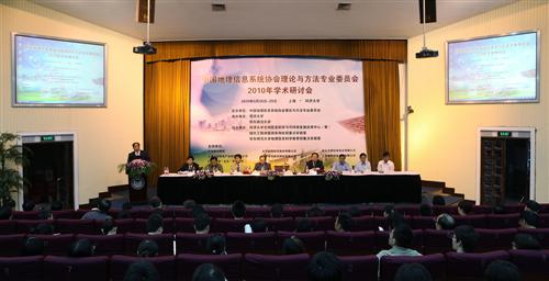
ͬ�ô�ѧ�а�GIS�����뷽��רҵίԱ��2010ѧ�����ֻᣨͼ��
�й�������ϢϵͳЭ�������뷽��רҵίԱ�� ͬ�ô�ѧ GIS�����뷽��רҵίԱ�� 2010 ѧ�����ֻ�
2010/10/12
2010��9��28����29�գ����й�������ϢϵͳЭ�������뷽��רҵίԱ��2010��ѧ�����ֻᡱ ����У�ٿ����������й�������ϢϵͳЭ�������뷽��רҵίԱ�����죬ͬ�ô�ѧ������ʦ����ѧ�а졣�����ԡ�GIS������������á�Ϊ���⣬���ר��Χ�Ƶ�����Ϣ��ѧ���ռ����ݴ�����GIS���̡��ռ������������Ϣ����GIS�¼���Ӧ�ü�ң�С�GPSӦ��ǰ�����ۺͼ���������������뽻����ϵͳ���֣��Դٽ��ҹ�GIS����...
������о��Ŷ�����Web GIS: Principles and Applications��ESRI���������
������о��Ŷ� Web GIS: Principles and Applications ESRI������ ����
2010/10/11
��Ʒ�º�����ֺ����ġ�Web GIS: Principles and Applications����Web GIS��һѸ�ͷ�չ�������ڸ��ԭ�������۷��������̽�������鹲ʮ�£���Web GIS������ȫ��ϵͳ�Ľ��ܡ����������ܺͷ������¸�����¼�����������Web�����ر���REST���͵�Web����������������Ƽ��㡢������Ϣ�Ż���վ����Ϣ�ۺϣ�mashup�����ƶ�GIS������2.0����ҵ���ܡ�...
�й��о����������а�-��
- ���ڼ���...
�й�ѧ���ڿ����а�-��
- ���ڼ���...
�����ѧ���л������а�-��
- ���ڼ���...
�й���ѧ���а�-��
- ���ڼ���...
�ˡ���-ƪ
- ���ڼ���...
�Ρ���-ƪ
- ���ڼ���...
��������-ƪ
- ���ڼ���...
�������� -ƪ
- ���ڼ���...
֪ʶҪ��-ƪ
- ���ڼ���...
���ʶ�̬-ƪ
- ���ڼ���...
��������-ƪ
- ���ڼ���...
ѧ��ָ��-ƪ
- ���ڼ���...
ѧ��վ��-ƪ
- ���ڼ���...