
搜索结果: 1-15 共查到“理学 Elevation”相关记录46条 . 查询时间(0.134 秒)
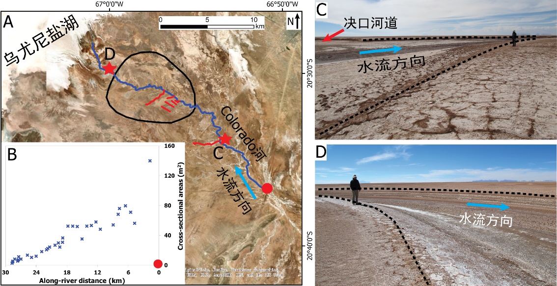
中国地质大学科学技术发展院李嘉光* 等,资源学院. Journal of Hydrology(2020), Digital Elevation Models for topographic characterisation and flood flow modelling along low-gradient, terminal dryland rivers: A comparison of spaceborne datasets for the Río Colorado, Bolivia(图)
精确表征;极低;缓河流;末端;地形;模拟河道;洪水;漫溢
2021/10/15
近日,国际知名期刊Journal of Hydrology在线刊发了中国地质大学资源学院李嘉光副教授团队在陆相湖盆边缘河流末端沉积体系研究的最新成果――Digital Elevation Models for topographic characterisation and flood flow modelling along low-gradient, terminal dryland rive...
THE RESEARCH ON ELEVATION CHANGE OF ANTARCTIC ICE SHEET BASED ON CRYOSAT-2 ALIMETER
Antarctic Ice Sheet, Cryosat-2,Satellite Altimetry,DEM, Crossover Adjustment,Kriging Interpolation, Intersection
2018/5/15
In this paper, the Cryosat-2 altimeter data distributed by the ESA, and these data are processed to extract the information of the elevation change of the Antarctic ice sheet from 2010 to 2017. Firstl...
Tropical lowland frogs at greater risk from climate warming than high-elevation species,study shows
Tropical lowland frogs greater risk climate warming high-elevation species
2017/4/27
A new study of Peruvian frogs living at a wide variety of elevations―from the Amazon floodplain to high Andes peaks―lends support to the idea that lowland amphibians are at higher risk from future cli...
OPEN-SOURCE DIGITAL ELEVATION MODEL (DEMs) EVALUATION WITH GPS AND LiDAR DATA
Digital Elevation Model inundation mapping vertical accuracy LiDAR scale factor coastal inundation risk assessment
2016/10/14
Advanced Spaceborne Thermal Emission and Reflection Radiometer-Global Digital Elevation Model (ASTER GDEM), Shuttle Radar Topography Mission (SRTM), and Global Multi-resolution Terrain Elevation Data ...
INFLUENCE OF RIVER BED ELEVATION SURVEY CONFIGURATIONS AND INTERPOLATION METHODS ON THE ACCURACY OF LIDAR DTM-BASED RIVER FLOW SIMULATIONS
LiDAR Digital Terrain Model River Bed Survey Configuration Interpolation Integration Flow Simulation
2016/10/14
In this paper, we investigated how survey configuration and the type of interpolation method can affect the accuracy of river flow simulations that utilize LIDAR DTM integrated with interpolated river...
Newly discovered reptile fossils offer clues about elevation history of Andes Mountains and climate change
reptile fossils elevation history Andes Mountains climate change
2016/1/8
On an arid plateau in the Andes Mountains of southern Bolivia, a Case Western Reserve University researcher flagged what turned out to be the fossil remains of a tortoise nearly five feet long―a find ...
Digital elevation models for landslide evolution monitoring: application on two areas located in the Reno River Valley (Italy)
Digital Elevation Model landslide GPS digital photogrammetry laser scanning
2015/9/15
GPS, digital photogrammetry and laser scanning techniques have been applied and compared in the frame of the studies of two complex landslides located in the Emilia-Romagna Region (Northern Italy). Th...
Practical use of SRTM digital elevation dataset in the urban-watershed modeling
SRTM-DEM Watershed modeling Hydrological model HEC-GeoHMS
2015/8/14
The advent of satellite-based elevation dataset acquired by Shuttle Radar Topography Mission (SRTM) made new and novel techniques possible to model hydrological process in midsize to large scale water...
Improving overland flow routing by incorporating ancillary road data into Digital Elevation Models
Watershed Delineation Road Geographic Information System GIS Flow Direction Digital Elevation Model DEM Hydrological Modeling
2015/8/6
Roads, ditches, and culverts influence hydrological and geomorphological processes significantly. However, most hydrological models continue to rely solely on regional digital elevation models (DEMs) ...
Paleontologists have documented how dramatic shifts in climate have led to dramatic shifts in evolution. One such event, the Grande Coupure, was a wipeout of many European mammal species 33.9 million ...
Practical use of SRTM digital elevation dataset in the urban-watershed modeling
Watershed modeling Hydrological model HEC-GeoHMS
2015/1/8
The advent of satellite-based elevation dataset acquired by Shuttle Radar Topography Mission (SRTM) made new and novel techniques possible to model hydrological process in midsize to large scale water...
Improving overland flow routing by incorporating ancillary road data into Digital Elevation Models
Watershed Delineation Road
2015/1/4
Roads, ditches, and culverts influence hydrological and geomorphological processes significantly. However, most hydrological models continue to rely solely on regional digital elevation models (DEMs) ...
An inventory of topographic surface changes: the value of multi-temporal elevation data for change analysis and monitoring
DEM/DTM Geomorphology Change Detection SAR, Multitemporal Monitoring Accuracy Error
2014/7/23
Landscape change resulting from human activities continues to be a primary topic in geographic research. Many studies have focused upon human-induced changes in two dimensions, namely in land cover. H...
Hot mantle drives elevation, volcanism along mid-ocean ridges
Hot mantle drives elevation volcanism along mid-ocean ridges
2014/4/16
By analyzing the speed of seismic waves generated by earthquakes, scientists have shown that temperature differences deep within Earth’s mantle control the elevation and volcanic activity along mid-o...
An analysis of marathon pacing and elevation change is presented. It is based on an empirical observation of how the pace of elite and non-elite marathon runners change over the course of the marathon...